1940s Maps of Excelsior Township, Michigan
Explore 2 historic maps of Excelsior Township from the 1940s. These maps offer a rare glimpse into what life looked like during the 1940s — showing old roads, neighborhoods, homes, and landmarks that have changed or disappeared over time.
Whether you're researching your family's past, planning a metal detecting trip, or studying how Excelsior Township's landscape evolved across the 1940s, these high-resolution maps are a powerful tool for exploring the history of this region.
- Focus on a specific era: All maps on this page are from the 1940s, giving you a focused view of this time period.
- See what’s changed: Compare century-old streets, trails, and buildings to today's modern landscape using overlays and satellite layers.
- Research with precision: Use these maps for genealogy, historical research, land use analysis, or educational projects.
- View, download, or print: Maps are fully viewable online in high resolution, and can be downloaded or printed for your own records.
Start exploring Excelsior Township's history through authentic maps from the 1940s. This is your window into the past.
Excelsior Township, MI maps
(2)- 1949 Map of Black Creek, 1953 Print
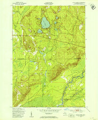 1949 Black Creek1953 Print · USGSUpper Michigan's interior is seen here just after the war, where state forest lands and military training grounds meet. Researchers can trace the path of the Manistee River and locate specific sites like Camp Grayling or the series of Upper Black Lakes.4 unique versions available
 - 1949 Map of Fletcher, 1955 Print
 1949 Fletcher1955 Print · USGSUpper Michigan's glacial interior is revealed here just after the war, showing the early infrastructure of the Camp Grayling area. Genealogists and historians can trace the New York Central tracks, the settlement of Fletcher, and local landmarks like Beaver Creek Cem.
End of results
Showing maps 1-2 of 2
Top cities near Excelsior Township
Top neighborhoods of Excelsior Township
Frequently asked questions
- What are the different types of historical maps available for Excelsior Township?
- What is the oldest map of Excelsior Township?
- Where can I purchase historical maps of Excelsior Township for my home or office?
- Where can I download high-res historical maps of Excelsior Township?
- Are there historical topographic maps available for Excelsior Township?
- Is there historical aerial imagery available for Excelsior Township?
- Where are historical maps of Excelsior Township sourced from?