
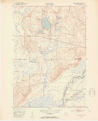
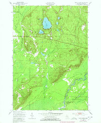
1949 Map of Black Creek
USGS Topo · Published 1953About this map
Bear Lake and its surrounding glacial kettle lakes dominate this Michigan interior during the mid-twentieth century, showing a landscape defined by state forestry and military training. Much of the southern quadrangle is occupied by the Camp Grayling Military Reservation, a key site for the Michigan National Guard, which borders the winding Manistee River. The river corridor is flanked by the Richardson Swamp, while the northern hills are heavily forested under the joint designation of the Au Sable State Forest Higgins Lake State Forest. Local water systems including Black Creek, Mallard Lake, and the series of Upper Black Lakes provide a clear view of the region's hydrology before modern development. In an area otherwise defined by natural features, the presence of unidentified Ruins suggests the site of previous structures or encampments.
Find a feature on this map
17 named features on this map. Tap any name to fly to it.
Don’t see what you’re looking for? This feature index may not catch every label — zoom into the map to look around manually.
Map Details
Editions of this 1949 Black Creek Map
4 editions found

Other maps of this area

1949 · Fletcher
USGS Topo · 1:62,500

1950 · Cote Dame Marie
USGS Topo · 1:24,000

1950 · Fletcher
USGS Topo · 1:24,000

1950 · Lake Margrethe
USGS Topo · 1:24,000

1954 · Traverse City
USGS Topo · 1:250,000

1956 · Alba
USGS Topo · 1:62,500

1956 · Mancelona
USGS Topo · 1:62,500

1956 · Kalkaska
USGS Topo · 1:62,500

1958 · Traverse City
USGS Topo · 1:250,000

1983 · Traverse City
USGS Topo · 1:100,000
Featured Places
- Excelsior Township, MI
- Bear Lake Township, MI
- Oliver Township, MI
- Pemberthy Crossing, MI
- Kalkaska County, MI