2020s Maps of Tyrone Township, Michigan
Explore 4 historic maps of Tyrone Township from the 2020s. These maps offer a rare glimpse into what life looked like during the 2020s — showing old roads, neighborhoods, homes, and landmarks that have changed or disappeared over time.
Whether you're researching your family's past, planning a metal detecting trip, or studying how Tyrone Township's landscape evolved across the 2020s, these high-resolution maps are a powerful tool for exploring the history of this region.
- Focus on a specific era: All maps on this page are from the 2020s, giving you a focused view of this time period.
- See what’s changed: Compare century-old streets, trails, and buildings to today's modern landscape using overlays and satellite layers.
- Research with precision: Use these maps for genealogy, historical research, land use analysis, or educational projects.
- View, download, or print: Maps are fully viewable online in high resolution, and can be downloaded or printed for your own records.
Start exploring Tyrone Township's history through authentic maps from the 2020s. This is your window into the past.
Tyrone Township, MI maps
(4)- 2023 Map of Casnovia, 2023 Print
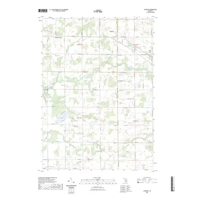 2023 Casnovia2023 Print · USGSCasnovia and Kent City sit at the intersection of three counties during the early twenty-first century, preserving a landscape of rural townships. Genealogists can trace family footprints across numerous local burial grounds, including Lisbon Cem, Hilton Cem, and the Saint Francis Xavier Church Cem.
 - 2023 Map of Sand Lake SW, 2023 Print
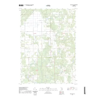 2023 Sand Lake SW2023 Print · USGSThis rural area on the Newaygo and Kent county line reflects a landscape of active agriculture and glacial lakes in the early twenty-first century. Genealogists and hikers can locate the Hillside Cem and trace the winding path of the North Country National Scenic Trail past Moore Lake.
 - 2023 Map of Sparta, 2023 Print
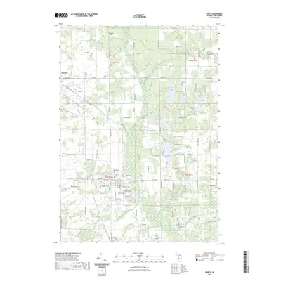 2023 Sparta2023 Print · USGSThe villages of Sparta and Kent City are captured here at the start of the 2020s, surrounded by a dense network of country roads and glacial lakes. Researchers can trace family history through several local landmarks like Greenwood Cemetery, Idlewild Cemetery, and Bettes Tower Hill.
 - 2023 Map of Grant, 2023 Print
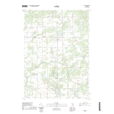 2023 Grant2023 Print · USGSNewaygo County and its surrounding rural townships are shown here in modern detail, capturing the agricultural character of western Michigan. Researchers can locate several family cemeteries and small-town centers like Ashland Center, Grant, and Shippy Cem.
End of results
Showing maps 1-4 of 4
Top cities near Tyrone Township
- Grand Rapids historical maps
- Plainfield Charter Township historical maps
- Walker historical maps
- Ada Township historical maps
- Cannon Township historical maps
- Alpine Township historical maps
See more
Top neighborhoods of Tyrone Township
Frequently asked questions
- What are the different types of historical maps available for Tyrone Township?
- What is the oldest map of Tyrone Township?
- Where can I purchase historical maps of Tyrone Township for my home or office?
- Where can I download high-res historical maps of Tyrone Township?
- Are there historical topographic maps available for Tyrone Township?
- Is there historical aerial imagery available for Tyrone Township?
- Where are historical maps of Tyrone Township sourced from?