1900s (20th Century) Maps of Eagle Harbor Township, Michigan
Explore 36 historic maps of Eagle Harbor Township from the 1900s (20th Century). These maps offer a rare glimpse into what life looked like during the 1900s — showing old roads, neighborhoods, homes, and landmarks that have changed or disappeared over time.
Whether you're researching your family's past, planning a metal detecting trip, or studying how Eagle Harbor Township's landscape evolved across the 1900s, these high-resolution maps are a powerful tool for exploring the history of this region.
- Focus on a specific era: All maps on this page are from the 1900s, giving you a focused view of this time period.
- See what’s changed: Compare century-old streets, trails, and buildings to today's modern landscape using overlays and satellite layers.
- Research with precision: Use these maps for genealogy, historical research, land use analysis, or educational projects.
- View, download, or print: Maps are fully viewable online in high resolution, and can be downloaded or printed for your own records.
Start exploring Eagle Harbor Township's history through authentic maps from the 1900s. This is your window into the past.
Eagle Harbor Township, MI maps
(36)- 1938 Map of Bruneau Creek
 1938 Bruneau Creek1938 Print · USGSThe northern Keweenaw Peninsula in the late 1930s is revealed here as a landscape of dense waterways and early settlements. Researchers can locate Preasville and trace the paths of the Bruneau River, Tobacco River, and the heights of Mt Horace Greeley.
 - 1938 Map of Delaware
 1938 Delaware1938 Print · USGSThe Keweenaw Peninsula in the late 1930s shows a landscape of mining-era remnants and early coastal tourism. Genealogists and historians can trace the small settlements of Delaware and Mandan, or follow the Old Railroad Grade past Lac La Belle.
 - 1939 Map of Deer Lake
 1939 Deer Lake1939 Print · USGSThe Keweenaw Peninsula shore in the late thirties shows a landscape of remote schools and winding river systems. Trace early landmarks like the Betsy River Sch, the waters of Lac La Belle, and the rocky shoreline at Black Rock Pt.
 - 1939 Map of Delaware
 1939 Delaware1939 Print · USGSKeweenaw's copper country is shown in the late thirties, featuring the inland settlements and dramatic shoreline ridges. Trace the industrial landscape through the old Railroad Grade at Delaware and the scenic Brockway Mountain Drive.
 - 1940 Map of Deer Lake
 1940 Deer Lake1940 Print · USGSThe Keweenaw Peninsula shoreline comes alive in the late 1930s as aerial photography reveals the remote coastal reaches of Lake Superior. Researchers can trace the drainage of the Big Betsy River or locate the site of the Betsy River Sch and Black Rock Pt.
 - 1940 Map of Central
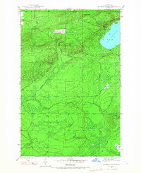
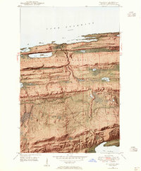
 1940 Central1940 Print · USGSKeweenaw Peninsula's rugged copper country comes into focus in this pre-war survey of the Lake Superior coastline. Genealogists and historians can trace the legacy of mining at Central and Copper Falls or locate the historic Eagle Harbor L H and the local Central Fire Tower.
 - 1940 Map of Lake Medora
 1940 Lake Medora1940 Print · USGSKeweenaw's rugged northern tip is captured in the 1940s as a landscape of mining history and new tourism. Trace the early routes of Brockway Mountain Drive and find the site of Aetna near Lake Manganese.
 - 1946 Map of Bruneau Creek, 1967 Print
 1946 Bruneau Creek1967 Print · USGSThe Keweenaw Peninsula interior comes into focus during the mid-forties, showing the wild drainage basins between Houghton and Sherman. Trace the intricate water networks of Lake Gratiot, the slopes of Mt Horace Greeley, and the headwaters of the Tobacco River.3 unique versions available
 - 1946 Map of Eagle Harbor, 1968 Print
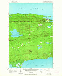
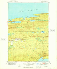
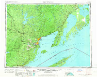
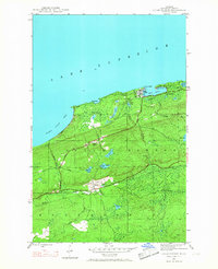 1946 Eagle Harbor1968 Print · USGSThe Keweenaw Peninsula coastline in the mid-1940s reveals a landscape defined by maritime safety and the aging infrastructure of the copper boom. Researchers can locate the Eagle Harbor L H, trace the Old Railroad Grade, and find inland mining-era sites like Copper Falls and Central.3 unique versions available
 - 1948 Map of Eagle Harbor
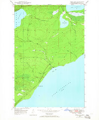
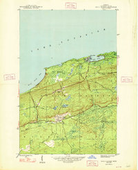 1948 Eagle Harbor1948 Print · USGSThe Keweenaw Peninsula's rugged mining and maritime culture is on full display in the late 1940s. Genealogists and historians can trace the foundations of Central and Copper Falls, or locate family sites near Pine Grove Cem and the Coast Guard Sta.2 unique versions available
 - 1948 Map of Bruneau Creek
 1948 Bruneau Creek1948 Print · USGSKeweenaw's rugged northern interior and Lake Superior shoreline are captured here in the late 1940s. Researchers can trace the winding paths of Bruneau Creek and the Tobacco River or locate the summit of Mt Horace Greeley.2 unique versions available
 - 1948 Map of Delaware, 1955 Print
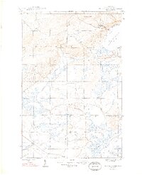
 1948 Delaware1955 Print · USGSKeweenaw County’s rugged northern tip appears in the late 1940s, from the rocky harbor at Agate Point down to the settlement at Delaware. You can trace the complex geography of the Montreal River valley and find early mining-era sites like Mandan and Lac La Belle.8 unique versions available
 - 1948 Map of Lake Medora, 1964 Print
 1948 Lake Medora1964 Print · USGSThe Keweenaw Peninsula's northern coast appears here in the late 1940s, balancing its mining history with emerging tourism. Researchers can trace the winding Brockway Mountain Drive and find landmarks like Ft Wilkins State Park and Mount Houghton.3 unique versions available
 - 1948 Map of Deer Lake, 1965 Print
 1948 Deer Lake1965 Print · USGSKeweenaw's rugged shoreline and interior waterways are captured here in the late 1940s as a new coastal road was first being carved. Researchers can trace the early path of the road UNDER CONSTRUCTION near Black Rock Point or locate the site of the Betsy River School.3 unique versions available
 - 1949 Map of Deer Lake
 1949 Deer Lake1949 Print · USGSKeweenaw Peninsula wilderness meets the coast of Lake Superior in the late 1940s. Genealogists and researchers can locate the Betsy River Sch and trace the early development of roads under construction near Black Rock Point.
 - 1949 Map of Lake Medora
 1949 Lake Medora1949 Print · USGSThe tip of Michigan's Keweenaw Peninsula comes alive in this late 1940s survey of the northern copper country. Trace the historic grounds of Ft Wilkins State Park, the heights of Mount Houghton, and the remote coastal settlement at Bete Grise.
 - 1949 Map of Delaware
 1949 Delaware1949 Print · USGSThe Keweenaw Peninsula’s rugged northern coast and interior ridges are captured here just after the war. Genealogists and local historians can locate the early settlements of Delaware and Mandan or trace the winding Montreal River toward Lac La Belle.4 unique versions available
 - 1958 Map of Hancock, 1967 Print
 1958 Hancock1967 Print · USGSThe Keweenaw Peninsula and Isle Royale are seen here during the mid-twentieth century as mining and maritime hubs. Trace the dense town layouts of Hancock and Calumet, or locate remote coastal markers like the Eagle Harbor Lighthouse and Rock of Ages Light.2 unique versions available
 - 1959 Map of Fort William, 1967 Print
 1959 Fort William1967 Print · USGSThe northern shore of Lake Superior at the close of the 1950s shows a thriving rail and shipping network connecting the twin ports and the remote island wilderness. Trace family roots and local industry in Port Arthur, Vickers Heights, and Isle Royale National Park.3 unique versions available
 - 1960 Map of Hancock
 1960 Hancock1960 Print · USGSThe Keweenaw Peninsula and Isle Royale are captured in detail during the late 1950s. Researchers can trace copper-mining era settlements like Calumet and Laurium, or locate remote maritime landmarks such as the Isle Royale Lighthouse.
 - 1961 Map of Hancock
 1961 Hancock1961 Print · USGSThe Keweenaw Peninsula and Isle Royale are shown here at the start of the 1960s, featuring the region's historic copper mining and maritime infrastructure. Genealogists and researchers can trace local families through settlements like Atlantic Mine and Painesdale, or locate remote landmarks including Rock of Ages Light and Eagle Harbor.
 - 1966 Map of Hancock, 1987 Print
 1966 Hancock1987 Print · USGSThe Keweenaw Peninsula and Isle Royale are captured in the mid-1960s during a pivotal era for Michigan’s Copper Country. Trace the industrial footprint of the SOO LINE through Calumet or locate historic maritime landmarks like Fort Wilkins and Rock of Ages Light.
 - 1968 Map of Fort William
 1968 Fort William1968 Print · USGSThe Canadian Lakehead and Isle Royale appear here in the late sixties, just before Port Arthur and Fort William merged. Genealogists can locate family lands near Rosslyn Village, Silver Mountain, and the Fort William Indian Reserve 52.
 - 1985 Map of Todd Harbor
 1985 Todd Harbor1985 Print · USGSIsle Royale is mapped here in the mid-1980s as a managed wilderness, illustrating the island's ridges and isolated interior lakes. Researchers can locate remote park facilities like the Park Headquarters and trace copper mining history at the Saginaw Mine and Mine Point.2 unique versions available
 - 1985 Map of Copper Harbor
 1985 Copper Harbor1985 Print · USGSThe northern tip of the Keweenaw Peninsula is captured in the mid-eighties, showing the rugged shoreline from Bete Grise to Keweenaw Point. Local historians can trace landmarks like Ft Wilkins State Park, Mount Houghton, and the isolated Manitou Island lighthouse.2 unique versions available
Showing maps 1-25 of 36
Top neighborhoods of Eagle Harbor Township
- Nepco Camp Number 7 historical maps
- Copper Falls historical maps
- Gratiot Lake Beach historical maps
- Eagle Harbor historical maps
Frequently asked questions
- What are the different types of historical maps available for Eagle Harbor Township?
- What is the oldest map of Eagle Harbor Township?
- Where can I purchase historical maps of Eagle Harbor Township for my home or office?
- Where can I download high-res historical maps of Eagle Harbor Township?
- Are there historical topographic maps available for Eagle Harbor Township?
- Is there historical aerial imagery available for Eagle Harbor Township?
- Where are historical maps of Eagle Harbor Township sourced from?