1940s Maps of Central, Houghton Township
Explore 3 historic maps of Central from the 1940s. These maps offer a rare glimpse into what life looked like during the 1940s — showing old roads, neighborhoods, homes, and landmarks that have changed or disappeared over time.
Whether you're researching your family's past, planning a metal detecting trip, or studying how Central's landscape evolved across the 1940s, these high-resolution maps are a powerful tool for exploring the history of this region.
- Focus on a specific era: All maps on this page are from the 1940s, giving you a focused view of this time period.
- See what’s changed: Compare century-old streets, trails, and buildings to today's modern landscape using overlays and satellite layers.
- Research with precision: Use these maps for genealogy, historical research, land use analysis, or educational projects.
- View, download, or print: Maps are fully viewable online in high resolution, and can be downloaded or printed for your own records.
Start exploring Central's history through authentic maps from the 1940s. This is your window into the past.
Central, Houghton Township maps
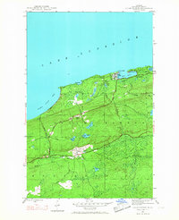
(3)- 1940 Map of Central
 1940 Central1940 Print · USGSKeweenaw Peninsula's rugged copper country comes into focus in this pre-war survey of the Lake Superior coastline. Genealogists and historians can trace the legacy of mining at Central and Copper Falls or locate the historic Eagle Harbor L H and the local Central Fire Tower.
 - 1946 Map of Eagle Harbor, 1968 Print
 1946 Eagle Harbor1968 Print · USGSThe Keweenaw Peninsula coastline in the mid-1940s reveals a landscape defined by maritime safety and the aging infrastructure of the copper boom. Researchers can locate the Eagle Harbor L H, trace the Old Railroad Grade, and find inland mining-era sites like Copper Falls and Central.3 unique versions available
 - 1948 Map of Eagle Harbor
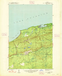 1948 Eagle Harbor1948 Print · USGSThe Keweenaw Peninsula's rugged mining and maritime culture is on full display in the late 1940s. Genealogists and historians can trace the foundations of Central and Copper Falls, or locate family sites near Pine Grove Cem and the Coast Guard Sta.2 unique versions available
End of results
Showing maps 1-3 of 3
Top cities near Central
- Allouez historical maps
- Lake Linden historical maps
- Eagle Harbor historical maps
- Copper City historical maps
- Ahmeek historical maps
Frequently asked questions
- What are the different types of historical maps available for Central?
- What is the oldest map of Central?
- Where can I purchase historical maps of Central for my home or office?
- Where can I download high-res historical maps of Central?
- Are there historical topographic maps available for Central?
- Is there historical aerial imagery available for Central?
- Where are historical maps of Central sourced from?