1930s Maps of Ellsworth Township, Michigan
Explore 4 historic maps of Ellsworth Township from the 1930s. These maps offer a rare glimpse into what life looked like during the 1930s — showing old roads, neighborhoods, homes, and landmarks that have changed or disappeared over time.
Whether you're researching your family's past, planning a metal detecting trip, or studying how Ellsworth Township's landscape evolved across the 1930s, these high-resolution maps are a powerful tool for exploring the history of this region.
- Focus on a specific era: All maps on this page are from the 1930s, giving you a focused view of this time period.
- See what’s changed: Compare century-old streets, trails, and buildings to today's modern landscape using overlays and satellite layers.
- Research with precision: Use these maps for genealogy, historical research, land use analysis, or educational projects.
- View, download, or print: Maps are fully viewable online in high resolution, and can be downloaded or printed for your own records.
Start exploring Ellsworth Township's history through authentic maps from the 1930s. This is your window into the past.
Ellsworth Township, MI maps
(4)- 1931 Map of Chase NE
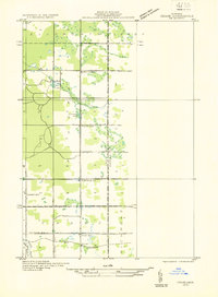 1931 Chase NE1931 Print · USGSOsceola and Lake counties appear in the early 1930s as a landscape of rural schoolhouses and rail-side settlements. Local historians can trace the foundations of Oliver along the Pere Marquette railroad or locate old school sites like Rosenburg Sch and Spears Sch.
 - 1932 Map of Chase NW
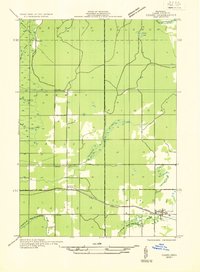 1932 Chase NW1932 Print · USGSLake County at the start of the 1930s was defined by its railroad hamlets and intersecting river systems. Researchers can locate the Cherry Valley Sch, trace the Pere Marquette tracks through Nirvana, and follow the Baldwin River.
 - 1933 Map of Luther SE
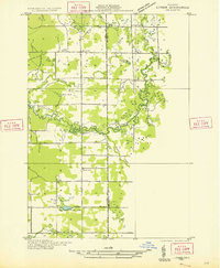 1933 Luther SE1933 Print · USGSOsceola County timberlands and river valleys are captured here during the early 1930s, showing a landscape defined by water and woods. Genealogists can locate family landmarks like the Dover Cem, Bristol, and rural schoolhouses including Keats Sch.
 - 1933 Map of Luther SW
 1933 Luther SW1933 Print · USGSThe Pine River and Little Manistee River wind through Lake County during the early 1930s, centering on the village of Luther. Genealogists and local historians can trace the grid of the village, the North Park Cem, and the old Voss Sch.
End of results
Showing maps 1-4 of 4
Top cities near Ellsworth Township
- Cadillac historical maps
- Haring Township historical maps
- Reed City historical maps
- Chase historical maps
- Baldwin historical maps
- Hersey historical maps
See more
Top neighborhoods of Ellsworth Township
Frequently asked questions
- What are the different types of historical maps available for Ellsworth Township?
- What is the oldest map of Ellsworth Township?
- Where can I purchase historical maps of Ellsworth Township for my home or office?
- Where can I download high-res historical maps of Ellsworth Township?
- Are there historical topographic maps available for Ellsworth Township?
- Is there historical aerial imagery available for Ellsworth Township?
- Where are historical maps of Ellsworth Township sourced from?