1930s Maps of Sauble Township, Michigan
Explore 4 historic maps of Sauble Township from the 1930s. These maps offer a rare glimpse into what life looked like during the 1930s — showing old roads, neighborhoods, homes, and landmarks that have changed or disappeared over time.
Whether you're researching your family's past, planning a metal detecting trip, or studying how Sauble Township's landscape evolved across the 1930s, these high-resolution maps are a powerful tool for exploring the history of this region.
- Focus on a specific era: All maps on this page are from the 1930s, giving you a focused view of this time period.
- See what’s changed: Compare century-old streets, trails, and buildings to today's modern landscape using overlays and satellite layers.
- Research with precision: Use these maps for genealogy, historical research, land use analysis, or educational projects.
- View, download, or print: Maps are fully viewable online in high resolution, and can be downloaded or printed for your own records.
Start exploring Sauble Township's history through authentic maps from the 1930s. This is your window into the past.
Sauble Township, MI maps
(4)- 1931 Map of Baldwin NW
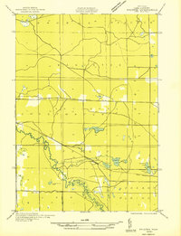 1931 Baldwin NW1931 Print · USGSLake County's timber and river country is captured here in the early thirties, just as federal forest management was taking hold. Researchers can locate the settlement of Wingleton, the local Town Hall, and the original path of U S Highway No 10.
 - 1931 Map of Custer NE
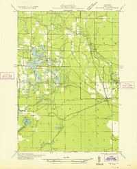
 1931 Custer NE1931 Print · USGSMason County in the early 1930s is a landscape of winding rivers and country schoolhouses. Genealogists and local historians can trace the foundations of Tallman and Walhalla, or locate landmarks like the Dunbar Fire Tower and the Swedish Settlement Sch.
 - 1932 Map of Freesoil SE
 1932 Freesoil SE1932 Print · USGSIn the early 1930s, Mason County’s inland river systems and timbered townships remained largely defined by their water-driven geography. Genealogists and local historians can trace family locations near Millerton, the Round Lake Sch, and the banks of the Big Sable River.2 unique versions available
 - 1933 Map of Peacock SW
 1933 Peacock SW1933 Print · USGSLake County was a landscape of winding rivers and hidden lakes in the early thirties as the region transitioned from logging to early recreation. Researchers can trace the rail-and-road connections at Peacock, locate the Bass Lake Sch, and find the Gremont Club near the Little Manistee River.
End of results
Showing maps 1-4 of 4
Top cities near Sauble Township
- Baldwin historical maps
- Peacock historical maps
- Sauble historical maps
- Wellston historical maps
- Free Soil historical maps
- Fountain historical maps
Top neighborhoods of Sauble Township
Frequently asked questions
- What are the different types of historical maps available for Sauble Township?
- What is the oldest map of Sauble Township?
- Where can I purchase historical maps of Sauble Township for my home or office?
- Where can I download high-res historical maps of Sauble Township?
- Are there historical topographic maps available for Sauble Township?
- Is there historical aerial imagery available for Sauble Township?
- Where are historical maps of Sauble Township sourced from?