1990s Maps of Lapeer County, Michigan
Explore 6 historic maps of Lapeer County from the 1990s. These maps offer a rare glimpse into what life looked like during the 1990s — showing old roads, neighborhoods, homes, and landmarks that have changed or disappeared over time.
Whether you're researching your family's past, planning a metal detecting trip, or studying how Lapeer County's landscape evolved across the 1990s, these high-resolution maps are a powerful tool for exploring the history of this region.
- Focus on a specific era: All maps on this page are from the 1990s, giving you a focused view of this time period.
- See what’s changed: Compare century-old streets, trails, and buildings to today's modern landscape using overlays and satellite layers.
- Research with precision: Use these maps for genealogy, historical research, land use analysis, or educational projects.
- View, download, or print: Maps are fully viewable online in high resolution, and can be downloaded or printed for your own records.
Start exploring Lapeer County's history through authentic maps from the 1990s. This is your window into the past.
Lapeer County, MI maps
(6)- 1990 Map of Flint, 1991 Print
 1990 Flint1991 Print · USGSThe Flint and Saginaw corridors are captured here in the early nineties, showing a landscape defined by heavy industry and rural expanses. Genealogists and historians can trace the rail lines of the Penn Central RR, visit Flint Memorial Park Cem, or explore the limits of Zilwaukee.
 - 1991 Map of Metamora
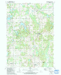 1991 Metamora1991 Print · USGSLapeer County's lake-studded landscape is captured here in the early nineties as rural homesteads and recreation areas define the terrain. Researchers can trace family history at Farmers Creek Cem, locate the village of Metamora, and find the D Bar A Scout Ranch.
 - 1991 Map of Almont
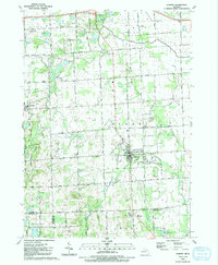 1991 Almont1991 Print · USGSAlmont and Dryden are captured in the early nineties at the junction of Lapeer, Macomb, and Oakland counties. Researchers can trace land use through numerous family burial sites like Hough Cem and community landmarks such as Gen Squier Mem Park.
 - 1991 Map of Hadley
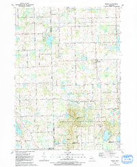 1991 Hadley1991 Print · USGSThe Lapeer County countryside around Hadley and the northern edge of Oakland County are shown in the early nineties as a landscape of glacial lakes and protected parkland. Genealogists can locate family sites near South Hadley Cem or trace rural properties along Pratt Road and Brigham Road.
 - 1991 Map of Allenton
 1991 Allenton1991 Print · USGSThe rural borderlands of St. Clair County are captured here in the early nineties, showing a landscape of established farms and quiet settlements. Local historians can locate Scotch Settlement, St Johns Ch, and the winding course of the Belle River.
 - 1991 Map of Thornville
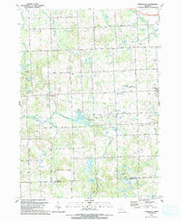 1991 Thornville1991 Print · USGSLapeer County in the early 1990s shows a landscape of glacial lakes and rural settlements centered on the village of Dryden. Researchers can trace the path of the GT RR or locate family history at the South Dryden Pioneer Cem and Thornville Cem.
End of results
Showing maps 1-6 of 6
Top cities of Lapeer County
Frequently asked questions
- What are the different types of historical maps available for Lapeer County?
- What is the oldest map of Lapeer County?
- Where can I purchase historical maps of Lapeer County for my home or office?
- Where can I download high-res historical maps of Lapeer County?
- Are there historical topographic maps available for Lapeer County?
- Is there historical aerial imagery available for Lapeer County?
- Where are historical maps of Lapeer County sourced from?