1990s Maps of Port Oneida, Glen Arbor Township
Explore 1 historic maps of Port Oneida from the 1990s. These maps offer a rare glimpse into what life looked like during the 1990s — showing old roads, neighborhoods, homes, and landmarks that have changed or disappeared over time.
Whether you're researching your family's past, planning a metal detecting trip, or studying how Port Oneida's landscape evolved across the 1990s, these high-resolution maps are a powerful tool for exploring the history of this region.
- Focus on a specific era: All maps on this page are from the 1990s, giving you a focused view of this time period.
- See what’s changed: Compare century-old streets, trails, and buildings to today's modern landscape using overlays and satellite layers.
- Research with precision: Use these maps for genealogy, historical research, land use analysis, or educational projects.
- View, download, or print: Maps are fully viewable online in high resolution, and can be downloaded or printed for your own records.
Start exploring Port Oneida's history through authentic maps from the 1990s. This is your window into the past.
Port Oneida, Glen Arbor Township maps
(1)- 1997 Map of Glen Arbor, 2000 Print
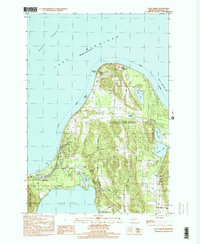 1997 Glen Arbor2000 Print · USGSThe Leelanau County coast is shown here in the late twentieth century, centered on the protected lands of Sleeping Bear Dunes. Genealogists and local historians can trace family ties at Kelderhouse Cem, explore the historic Port Oneida area, or follow the winding Crystal River.
End of results
Showing maps 1-1 of 1
Top cities near Port Oneida
- Long Lake Township historical maps
- Long Lake Charter Township historical maps
- Solon historical maps
- Leland historical maps
- Empire historical maps
- Lake Ann historical maps
See more
Frequently asked questions
- What are the different types of historical maps available for Port Oneida?
- What is the oldest map of Port Oneida?
- Where can I purchase historical maps of Port Oneida for my home or office?
- Where can I download high-res historical maps of Port Oneida?
- Are there historical topographic maps available for Port Oneida?
- Is there historical aerial imagery available for Port Oneida?
- Where are historical maps of Port Oneida sourced from?