2020s Maps of Suttons Bay Township, Michigan
Explore 4 historic maps of Suttons Bay Township from the 2020s. These maps offer a rare glimpse into what life looked like during the 2020s — showing old roads, neighborhoods, homes, and landmarks that have changed or disappeared over time.
Whether you're researching your family's past, planning a metal detecting trip, or studying how Suttons Bay Township's landscape evolved across the 2020s, these high-resolution maps are a powerful tool for exploring the history of this region.
- Focus on a specific era: All maps on this page are from the 2020s, giving you a focused view of this time period.
- See what’s changed: Compare century-old streets, trails, and buildings to today's modern landscape using overlays and satellite layers.
- Research with precision: Use these maps for genealogy, historical research, land use analysis, or educational projects.
- View, download, or print: Maps are fully viewable online in high resolution, and can be downloaded or printed for your own records.
Start exploring Suttons Bay Township's history through authentic maps from the 2020s. This is your window into the past.
Suttons Bay Township, MI maps
(4)- 2023 Map of Gills Pier, 2023 Print
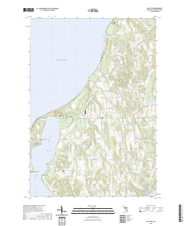 2023 Gills Pier2023 Print · USGSThe Leelanau Peninsula shoreline near Leland is documented here in the early twenty-first century, showcasing the area between Lake Leelanau and Lake Michigan. Genealogists and historians can locate several burial sites, including the Onominese Indian Cem and Saint Wenceslaus Cem.
 - 2023 Map of Mapleton, 2023 Print
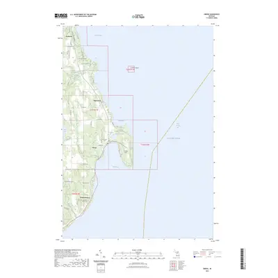
 2023 Mapleton2023 Print · USGSGrand Traverse Bay and the surrounding peninsulas are captured in this recent survey, showcasing the enduring coastal settlement patterns of Northern Michigan. Researchers can trace family history at Bowers Harbor Cem and explore the historic layout of Mapleton or the finger-like projection of Neah-Ta-Wanta Point.
 - 2023 Map of Omena, 2023 Print
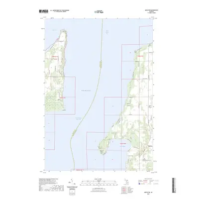
 2023 Omena2023 Print · USGSThe Leelanau Peninsula shoreline comes into focus in this contemporary survey of the communities bordering Grand Traverse Bay. Genealogists and local researchers can trace family landmarks and burial sites at Omena Presbyterian Cem or the Immaculate Conception Catholic Cem.
 - 2023 Map of Suttons Bay, 2023 Print
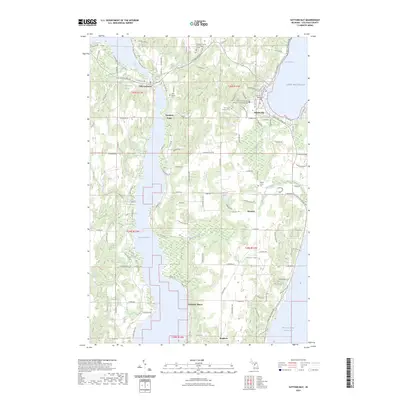 2023 Suttons Bay2023 Print · USGSSuttons Bay and the surrounding Leelanau peninsula are documented here during the early twenty-first century as agricultural and lakeside life intersect. Genealogists can locate family names at Saint Michael Cem and Maple Grove Cem or trace the shoreline from Fountain Point to Bingham.
End of results
Showing maps 1-4 of 4
Top cities near Suttons Bay Township
- Garfield Township historical maps
- Traverse City historical maps
- Long Lake Township historical maps
- Peninsula Township historical maps
- Elmwood Charter Township historical maps
- Acme historical maps
See more
Top neighborhoods of Suttons Bay Township
Frequently asked questions
- What are the different types of historical maps available for Suttons Bay Township?
- What is the oldest map of Suttons Bay Township?
- Where can I purchase historical maps of Suttons Bay Township for my home or office?
- Where can I download high-res historical maps of Suttons Bay Township?
- Are there historical topographic maps available for Suttons Bay Township?
- Is there historical aerial imagery available for Suttons Bay Township?
- Where are historical maps of Suttons Bay Township sourced from?