1960s Maps of Medina Township, Michigan
Explore 4 historic maps of Medina Township from the 1960s. These maps offer a rare glimpse into what life looked like during the 1960s — showing old roads, neighborhoods, homes, and landmarks that have changed or disappeared over time.
Whether you're researching your family's past, planning a metal detecting trip, or studying how Medina Township's landscape evolved across the 1960s, these high-resolution maps are a powerful tool for exploring the history of this region.
- Focus on a specific era: All maps on this page are from the 1960s, giving you a focused view of this time period.
- See what’s changed: Compare century-old streets, trails, and buildings to today's modern landscape using overlays and satellite layers.
- Research with precision: Use these maps for genealogy, historical research, land use analysis, or educational projects.
- View, download, or print: Maps are fully viewable online in high resolution, and can be downloaded or printed for your own records.
Start exploring Medina Township's history through authentic maps from the 1960s. This is your window into the past.
Medina Township, MI maps
(4)- 1960 Map of Morenci, 1961 Print
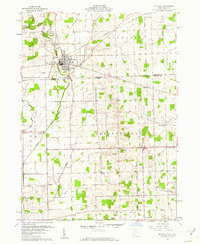 1960 Morenci1961 Print · USGSMorenci and the surrounding borderlands of Michigan and Ohio are shown here in the early sixties, as rail lines and rural townships defined the local economy. Genealogists can trace family names through Oak Grove Cemetery, East Chesterfield Ch, and the crossroads at Oakshade.3 unique versions available
 - 1960 Map of Fayette, 1961 Print
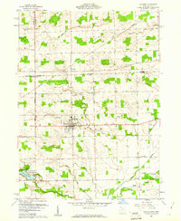 1960 Fayette1961 Print · USGSThe borderlands of Fulton County and Michigan come into focus in this 1960s survey of Fayette. Family historians can trace local landmarks like Snow Cem, the grounds of Camp Palmer, and the rural crossroads of Munson and Powers.4 unique versions available
 - 1962 Map of Clayton, 1963 Print
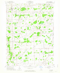 1962 Clayton1963 Print · USGSLenawee County’s rural townships are captured here in the early sixties, showing a landscape defined by rail lines and reclaimed farmland. Family historians can locate specific sites like South Dover Cem, Dover Center Ch, and the Grange Hall.3 unique versions available
 - 1962 Map of Hudson, 1963 Print
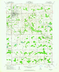 1962 Hudson1963 Print · USGSHudson and its surrounding townships thrive in the early sixties as a center of rail commerce and agriculture along the New York Central line. Genealogists and local historians can locate many family landmarks, from the Whitney Cem and Brown Cem to the early rural settlements of Medina and Prattville.3 unique versions available
End of results
Showing maps 1-4 of 4
Top cities near Medina Township
- Adrian historical maps
- Wauseon historical maps
- Archbold historical maps
- Rollin historical maps
- Rollin Township historical maps
- Hudson historical maps
See more
Top neighborhoods of Medina Township
Frequently asked questions
- What are the different types of historical maps available for Medina Township?
- What is the oldest map of Medina Township?
- Where can I purchase historical maps of Medina Township for my home or office?
- Where can I download high-res historical maps of Medina Township?
- Are there historical topographic maps available for Medina Township?
- Is there historical aerial imagery available for Medina Township?
- Where are historical maps of Medina Township sourced from?