1900s (20th Century) Maps of Genoa Charter Township, Michigan
Explore 8 historic maps of Genoa Charter Township from the 1900s (20th Century). These maps offer a rare glimpse into what life looked like during the 1900s — showing old roads, neighborhoods, homes, and landmarks that have changed or disappeared over time.
Whether you're researching your family's past, planning a metal detecting trip, or studying how Genoa Charter Township's landscape evolved across the 1900s, these high-resolution maps are a powerful tool for exploring the history of this region.
- Focus on a specific era: All maps on this page are from the 1900s, giving you a focused view of this time period.
- See what’s changed: Compare century-old streets, trails, and buildings to today's modern landscape using overlays and satellite layers.
- Research with precision: Use these maps for genealogy, historical research, land use analysis, or educational projects.
- View, download, or print: Maps are fully viewable online in high resolution, and can be downloaded or printed for your own records.
Start exploring Genoa Charter Township's history through authentic maps from the 1900s. This is your window into the past.
Genoa Charter Township, MI maps
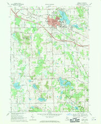
(8)- 1907 Map of Howell, 1959 Print
 1907 Howell1959 Print · USGSLivingston County is mapped here in the early twentieth century as a busy rail and agricultural center. Researchers can trace the legacy of rural education and industry through dozens of local sites like Jubb School, Parker Church, and the State Sanitarium.2 unique versions available
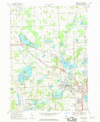
 - 1909 Map of Howell
 1909 Howell1909 Print · USGSLivingston County's landscape at the dawn of the century was defined by the crossing of major rail lines and the historic Grand River Road. Genealogists and local historians can trace the early sites of Oak Grove, Parshallyville, and the State Sanitarium.2 unique versions available
 - 1954 Map of Detroit
 1954 Detroit1954 Print · USGSThe Detroit metro and its Ontario neighbors are shown at the height of the mid-century industrial era, just as the suburbs were rapidly expanding. Researchers can trace the massive rail networks of the Wabash Railroad or locate landmarks like Grosse Ile and Selfridge Air Force Base.
 - 1961 Map of Detroit, 1973 Print
 1961 Detroit1973 Print · USGSThe international border between Michigan and Ontario was a bustling industrial corridor in the early sixties. Researchers can trace the transit networks and riverfront infrastructure connecting Detroit to Windsor via the Detroit-Windsor Tunnel and major air hubs like Willow Run Airport.2 unique versions available
 - 1965 Map of Detroit
 1965 Detroit1965 Print · USGSThe industrial corridor between Michigan and Ontario is captured here at mid-century, showing the dense rail and river networks of the Great Lakes. Local historians can trace the paths of the Grand Trunk Western RR and locate key landmarks like Selfridge Air Force Base and Grosse Ile.
 - 1968 Map of Howell, 1970 Print
 1968 Howell1970 Print · USGSHowell and its surrounding townships show a mix of civic growth and preserved wetlands during the late sixties. Researchers can trace historic family plots at Lakeview Cem and Mount Olivet Cem or locate institutional landmarks like the Howell State Hospital.3 unique versions available
 - 1968 Map of Brighton, 1970 Print
 1968 Brighton1970 Print · USGSLivingston County in the late sixties reveals a landscape of lakeside communities and growing recreational hubs. Genealogists and local historians can trace family markers at Chilson Cem, locate the old Birkenstock Sch, or study the rail operations of the Chesapeake and Ohio.3 unique versions available
 - 1985 Map of Pontiac
 1985 Pontiac1985 Print · USGSSoutheast Michigan in the mid-1980s shows a landscape of growing suburban corridors and expansive public parklands. Genealogists and local historians can trace the footprint of rail lines like the Grand Trunk Western or locate family sites near Oakwood Cem and White Chapel Cem.2 unique versions available
End of results
Showing maps 1-8 of 8
Top cities near Genoa Charter Township
- Lyon Charter Township historical maps
- Hamburg Township historical maps
- Green Oak Charter Township historical maps
- Highland Charter Township historical maps
- Brighton Charter Township historical maps
- Scio Township historical maps
See more
Top neighborhoods of Genoa Charter Township
Frequently asked questions
- What are the different types of historical maps available for Genoa Charter Township?
- What is the oldest map of Genoa Charter Township?
- Where can I purchase historical maps of Genoa Charter Township for my home or office?
- Where can I download high-res historical maps of Genoa Charter Township?
- Are there historical topographic maps available for Genoa Charter Township?
- Is there historical aerial imagery available for Genoa Charter Township?
- Where are historical maps of Genoa Charter Township sourced from?