
1907 Map of Howell
USGS Topo · Published 1959About this map
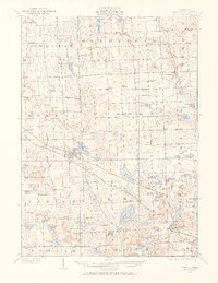
Howell serves as the central hub of this Livingston County survey, situated at the junction of the Pere Marquette and the Ann Arbor rail lines. The landscape is defined by its dense concentration of inland lakes and wetlands, particularly evident in the eastern townships of Oceola and Genoa. Notable water bodies like Lake Chemung and Thompson Lake sit alongside early infrastructure, including the State Sanitarium and the Town Hall in Genoa. Small rural centers such as Oak Grove, Parshallville, and Chilson provide a view of the county's early settlement patterns. A robust network of one-room schoolhouses, including Jubb School, Marr School, and Wolf School, is scattered across the townships, highlighting the decentralized nature of rural education at the time. Further south, Brighton appears as a growing rail town on the edge of a complex glacial lake system.
Find a feature on this map
83 named features on this map. Tap any name to fly to it.
Don’t see what you’re looking for? This feature index may not catch every label — zoom into the map to look around manually.
Map Details
Editions of this 1907 Howell Map
2 editions found
Other maps of this area

1902 · South Lyon
USGS Topo · 1:62,500

1902 · Dexter
USGS Topo · 1:62,500

1904 · Ann Arbor
USGS Topo · 1:125,000

1906 · Dexter
USGS Topo · 1:62,500

1906 · South Lyon
USGS Topo · 1:62,500

1908 · Ann Arbor
USGS Topo · 1:125,000

1908 · Fowlerville
USGS Topo · 1:62,500

1909 · Howell
USGS Topo · 1:62,500

1909 · Milford
USGS Topo · 1:62,500

1910 · Fowlerville
USGS Topo · 1:62,500
Featured Places
- Hamburg Township, MI
- Genoa Charter Township, MI
- Green Oak Charter Township, MI
- Brighton Charter Township, MI
- Hartland Township, MI