
1908 Map of Ann Arbor
USGS Topo · Published 1908About this map
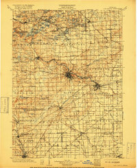
The Huron River carves a central path through this early twentieth-century landscape, anchoring the development of major hubs like Ann Arbor and Ypsilanti. During this era, the region was a dense nexus of steam and electric transport, where the Michigan Central RR and the Detroit and Chicago RR intersected with local lines such as the Detroit and Saline Electric RR. To the south, the Saline River and River Raisin support agricultural centers including Saline, Clinton, and Tecumseh, while the northern township of Hamburg is defined by a complex chain of glacial lakes like Whitmore Lake and Strawberry Lake.
Find a feature on this map
131 named features on this map. Tap any name to fly to it.
Don’t see what you’re looking for? This feature index may not catch every label — zoom into the map to look around manually.
Map Details
Editions of this 1908 Ann Arbor Map
This is the sole edition of this map. No revisions or reprints were ever made.
Historical Maps of Ann Arbor Through Time
Featured Locations
- Novi, MI
- Canton Township, MI
- Pittsfield Charter Township, MI
- Ann Arbor, MI
- Ypsilanti Charter Township, MI