
1902 Map of Ypsilanti
USGS Topo · Published 1958About this map
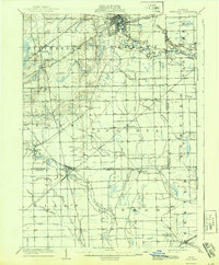
The Huron River winds through this early twentieth-century landscape, anchoring the bustling settlement of Ypsilanti. The area is a dense web of steam and electric transit, featuring the Michigan Central RR and the Detroit, Ypsilanti, Ann Arbor, and Jackson Electric RR, reflecting a time of rapid regional connectivity. Small farming communities and post offices like Rawsonville, Whittaker, and Oakville dot the township boundaries of Augusta and York. Southward, the map details the intersection of the Ann Arbor RR and the Wabash RR at the town of Milan, a critical rail junction. This survey documents the agrarian and industrial transition of Washtenaw and Monroe counties before the mid-century expansion of modern infrastructure, preserving the original courses of waterways like Willow Run and Paint Creek.
Find a feature on this map
46 named features on this map. Tap any name to fly to it.
Don’t see what you’re looking for? This feature index may not catch every label — zoom into the map to look around manually.
Map Details
Editions of this 1902 Ypsilanti Map
This is the sole edition of this map. No revisions or reprints were ever made.
Historical Maps of Ann Arbor Through Time
Featured Locations
- Van Buren Charter Township, MI
- Pittsfield Charter Township, MI
- Ann Arbor, MI
- Ypsilanti, MI
- Ypsilanti Charter Township, MI