
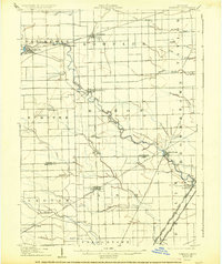
1906 Map of Romulus
USGS Topo · Published 1906About this map
Huron River meanders through this landscape, serving as a corridor for established villages and burgeoning industrial transport at the turn of the century. The settlement of Belleville and the rail-oriented French Landing stand as significant hubs in Van Buren township, while the central village of Romulus marks the intersection of the Wabash R R and Pere Marquette R R. The map captures a high density of rail activity in the southeast, where numerous lines including the Detroit Monroe and Toledo Short Line R R (Electric) and Grand Trunk R R converge near Rockwood and South Rockwood. Local drainage systems and family-named features like Whitaker Marsh Creek and Sutliff Drain reveal the agricultural character of the surrounding townships of Huron, Ash, and Taylor before modern development transformed the region.
Find a feature on this map
54 named features on this map. Tap any name to fly to it.
Don’t see what you’re looking for? This feature index may not catch every label — zoom into the map to look around manually.
Map Details
Editions of this 1906 Romulus Map
2 editions found
Other maps of this area

1902 · South Lyon
USGS Topo · 1:62,500

1902 · Ypsilanti
USGS Topo · 1:62,500

1904 · Ann Arbor
USGS Topo · 1:125,000

1905 · Wayne
USGS Topo · 1:62,500

1905 · Detroit
USGS Topo · 1:62,500

1906 · Ypsilanti
USGS Topo · 1:62,500

1906 · Wyandotte
USGS Topo · 1:62,500

1906 · South Lyon
USGS Topo · 1:62,500

1908 · Ann Arbor
USGS Topo · 1:125,000

1912 · Wyandotte
USGS Topo · 1:62,500
Featured Places
- Taylor, MI
- Brownstown Charter Township, MI
- Van Buren Charter Township, MI
- Romulus, MI
- Frenchtown Charter Township, MI