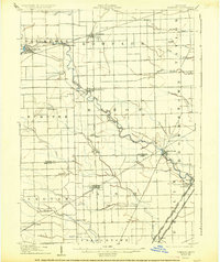
1906 Map of Romulus
USGS Topo · Published 1926About this map
The Huron River serves as the primary geographic corridor through this landscape, winding past established early 20th-century settlements like Belleville, New Boston, and Flat Rock. This survey, conducted just after the turn of the century, reveals a region defined by a dense industrial and agricultural transportation network. A remarkable concentration of rail lines converges here, including the Wabash RR, Pere Marquette RR, and the Michigan Central RR, illustrating the area's role as a vital junction between Detroit and the southern lake ports. Along the southern edge, the transition from Wayne Co to Monroe Co is marked by smaller farming communities such as Carleton and Waltz. Genealogists may find value in the specific placement of rural homesteads and named drainage features like Sutliff Drain and Whitaker Marsh Creek, which once defined property lines and local drainage districts in this low-lying territory.
Find a feature on this map
45 named features on this map. Tap any name to fly to it.
Don’t see what you’re looking for? This feature index may not catch every label — zoom into the map to look around manually.
Map Details
Editions of this 1906 Romulus Map
2 editions found
Other maps of this area

1902 · South Lyon
USGS Topo · 1:62,500

1902 · Ypsilanti
USGS Topo · 1:62,500

1904 · Ann Arbor
USGS Topo · 1:125,000

1905 · Wayne
USGS Topo · 1:62,500

1905 · Detroit
USGS Topo · 1:62,500

1906 · Ypsilanti
USGS Topo · 1:62,500

1906 · Wyandotte
USGS Topo · 1:62,500

1906 · South Lyon
USGS Topo · 1:62,500

1906 · Romulus
USGS Topo · 1:62,500

1908 · Ann Arbor
USGS Topo · 1:125,000
Featured Places
- Taylor, MI
- Brownstown Charter Township, MI
- Van Buren Charter Township, MI
- Romulus, MI
- Frenchtown Charter Township, MI