1928 Map of Romulus
USGS Topo · Published 1928About this map
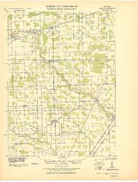
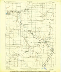
Huron River meanders southeastward across this landscape, serving as a primary corridor for development between Belleville and Flat Rock. The region exhibits a sophisticated transit network defined by the convergence of several major rail lines, including the Wabash RR, the Pere Marquette RR, and the Detroit Toledo And Ironton RR. These tracks intersect at strategic junctions such as Romulus and Carleton, supporting a cluster of agricultural and industrial settlements. Smaller outposts like French Landing and New Boston sit directly along the river's path, while the southern portion of the map is defined by an extensive drainage system, featuring Stony Creek, Wells Drain, and Robert Drain. The layout illustrates the transformation of Wayne and Monroe Counties into a vital transportation hub connecting Detroit to the south and west.
Find a feature on this map
46 named features on this map. Tap any name to fly to it.
Don’t see what you’re looking for? This feature index may not catch every label — zoom into the map to look around manually.
Map Details
Editions of this 1928 Romulus Map
This is the sole edition of this map. No revisions or reprints were ever made.
Historical Maps of Taylor Through Time
Featured Locations
- Frenchtown Charter Township, MI
- Brownstown Charter Township, MI
- Van Buren Charter Township, MI
- Romulus, MI
- Taylor, MI