
Loading...
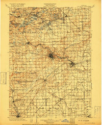
Loading map...1904 Map of Ann Arbor
USGS Topo · Published 1904About this map
The Huron River valley serves as the central artery for this early twentieth-century survey, anchoring the development of Ann Arbor and Ypsilanti. The landscape is defined by an intricate network of transit, where the Michigan Central R. R. and Ann Arbor R. R. meet a burgeoning system of interurban lines, such as the Ann Arbor and Saline Electric R. R. and the Detroit Electric R. R.. This convergence of steam and electric rail highlights the era's rapid connectivity between rural townships and growing urban centers.
Find a feature on this map
143 named features on this map. Tap any name to fly to it.
Don’t see what you’re looking for? This feature index may not catch every label — zoom into the map to look around manually.
Map Details
Date Portrayed1904
Date Published1904
PublisherU.S. Geological Survey
Map TypeTopographic
Scale1:125,000
Physical Dimensions16.5 x 19.8 inches
Editions of this 1904 Ann Arbor Map
2 editions found
Historical Maps of Ann Arbor Through Time

Featured Locations
- Novi, MI
- Canton Township, MI
- Pittsfield Charter Township, MI
- Ann Arbor, MI
- Ypsilanti Charter Township, MI
Source Details
SourceU.S. Geological Survey
CopyrightPublic Domain