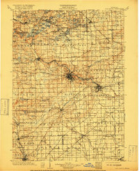
1904 Map of Ann Arbor
USGS Topo · Published 1917About this map
The Huron River serves as the central artery for this early twentieth-century survey of Washtenaw County and its neighbors, anchoring the regional economy of settlements like Ann Arbor and Ypsilanti. The landscape is defined by its transition from the dense cluster of glacial lakes in the northwest, including Whitmore Lake and Portage Lake, to the established agricultural and industrial corridors in the south and east. A complex transportation network is visible, where heavy rail lines like the Michigan Central R.R. and Grand Trunk R.R. operate alongside the burgeoning Electric R.R. system connecting smaller hubs.
Find a feature on this map
148 named features on this map. Tap any name to fly to it.
Don’t see what you’re looking for? This feature index may not catch every label — zoom into the map to look around manually.
Map Details
Editions of this 1904 Ann Arbor Map
2 editions found
Other maps of this area

1902 · South Lyon
USGS Topo · 1:62,500

1902 · Ypsilanti
USGS Topo · 1:62,500

1902 · Dexter
USGS Topo · 1:62,500

1904 · Ann Arbor
USGS Topo · 1:125,000

1905 · Wayne
USGS Topo · 1:62,500

1906 · Ypsilanti
USGS Topo · 1:62,500

1906 · Dexter
USGS Topo · 1:62,500

1906 · Saline
USGS Topo · 1:62,500

1906 · South Lyon
USGS Topo · 1:62,500

1906 · Romulus
USGS Topo · 1:62,500
Featured Places
- Ann Arbor, MI
- Canton Township, MI
- Novi, MI
- Ypsilanti Charter Township, MI
- Pittsfield Charter Township, MI