
1902 Map of Dexter
USGS Topo · Published 1962About this map
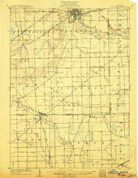
The Huron River winds through the heart of this landscape at the dawn of the twentieth century, serving as the primary geographic anchor for a network of riverside settlements and milling sites. Significant industrial activity is evident at Hudson Mills and Delhi Mills, where the river's power was harnessed alongside the Michigan Central R. R. corridor. The northern portion of the survey is dominated by a complex glaciated lake system, including Strawberry Lake, Zukey Lake, and Portage Lake, which helped shape the early development of Lakeland and Hamburg.
Find a feature on this map
76 named features on this map. Tap any name to fly to it.
Don’t see what you’re looking for? This feature index may not catch every label — zoom into the map to look around manually.
Map Details
Editions of this 1902 Dexter Map
This is the sole edition of this map. No revisions or reprints were ever made.
Other maps of this area

1902 · South Lyon
USGS Topo · 1:62,500

1902 · Ypsilanti
USGS Topo · 1:62,500

1904 · Ann Arbor
USGS Topo · 1:125,000
1906 · Ypsilanti
USGS Topo · 1:62,500

1906 · Dexter
USGS Topo · 1:62,500

1906 · Saline
USGS Topo · 1:62,500

1906 · South Lyon
USGS Topo · 1:62,500

1907 · Howell
USGS Topo · 1:62,500

1908 · Ann Arbor
USGS Topo · 1:125,000

1908 · Fowlerville
USGS Topo · 1:62,500
Featured Places
- Ann Arbor, MI
- Pittsfield Charter Township, MI
- Hamburg Township, MI
- Green Oak Charter Township, MI
- Scio Township, MI