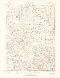
1907 Map of Howell
USGS Topo · Published 1965About this map
The county seat of Howell serves as a major rail junction at the turn of the century, where the Ann Arbor RR crosses the Pere Marquette RR. This convergence of transportation lines anchored the commercial life of Livingston County, supporting outlying settlements like Oak Grove and Parshallville. The landscape is defined by its post-glacial hydrology, featuring a dense concentration of kettle lakes such as Lake Chemung, Thompson Lake, and School Lake. To the west, the State Sanitarium occupies a prominent position near the headwaters of the Cedar River. The map meticulously records the rural infrastructure of the era, from the Parker Church to numerous local education centers like Marr School and Genoa School, providing a clear view of the social geography before the modern highway era reshaped these lakefront communities.
Find a feature on this map
87 named features on this map. Tap any name to fly to it.
Don’t see what you’re looking for? This feature index may not catch every label — zoom into the map to look around manually.
Map Details
Editions of this 1907 Howell Map
2 editions found
Other maps of this area

1902 · South Lyon
USGS Topo · 1:62,500

1902 · Dexter
USGS Topo · 1:62,500

1904 · Ann Arbor
USGS Topo · 1:125,000

1906 · Dexter
USGS Topo · 1:62,500

1906 · South Lyon
USGS Topo · 1:62,500

1907 · Howell
USGS Topo · 1:62,500

1908 · Ann Arbor
USGS Topo · 1:125,000

1908 · Fowlerville
USGS Topo · 1:62,500

1909 · Howell
USGS Topo · 1:62,500

1909 · Milford
USGS Topo · 1:62,500
Featured Places
- Hamburg Township, MI
- Genoa Charter Township, MI
- Green Oak Charter Township, MI
- Brighton Charter Township, MI
- Hartland Township, MI