1940s Maps of Brevort Township, Michigan
Explore 2 historic maps of Brevort Township from the 1940s. These maps offer a rare glimpse into what life looked like during the 1940s — showing old roads, neighborhoods, homes, and landmarks that have changed or disappeared over time.
Whether you're researching your family's past, planning a metal detecting trip, or studying how Brevort Township's landscape evolved across the 1940s, these high-resolution maps are a powerful tool for exploring the history of this region.
- Focus on a specific era: All maps on this page are from the 1940s, giving you a focused view of this time period.
- See what’s changed: Compare century-old streets, trails, and buildings to today's modern landscape using overlays and satellite layers.
- Research with precision: Use these maps for genealogy, historical research, land use analysis, or educational projects.
- View, download, or print: Maps are fully viewable online in high resolution, and can be downloaded or printed for your own records.
Start exploring Brevort Township's history through authentic maps from the 1940s. This is your window into the past.
Brevort Township, MI maps
(2)- 1948 Map of Moran NE
 1948 Moran NE1948 Print · USGSMackinac County's forested interior meets the Lake Michigan shoreline in the 1930s, as the timber and rail era began to embrace tourism. Genealogists and historians can trace old homesteads near Moran, St Marys Cem, and the tracks of the Duluth South Shore and Atlantic railroad.
 - 1948 Map of Moran NW
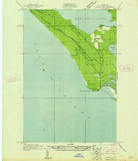 1948 Moran NW1948 Print · USGSMackinac County's shoreline near the mid-century remains a landscape of prominent points and inland waters. Researchers can trace the path of Old Peter Road and White Trail as they lead toward Brevoort Lake and the coastal Pte Aux Chenes.
End of results
Showing maps 1-2 of 2
Top cities near Brevort Township
- Saint Ignace historical maps
- Moran historical maps
- Brevort historical maps
- Trout Lake historical maps
- Mackinac Island historical maps
Top neighborhoods of Brevort Township
Frequently asked questions
- What are the different types of historical maps available for Brevort Township?
- What is the oldest map of Brevort Township?
- Where can I purchase historical maps of Brevort Township for my home or office?
- Where can I download high-res historical maps of Brevort Township?
- Are there historical topographic maps available for Brevort Township?
- Is there historical aerial imagery available for Brevort Township?
- Where are historical maps of Brevort Township sourced from?