1960s Maps of Hendricks Township, Michigan
Explore 4 historic maps of Hendricks Township from the 1960s. These maps offer a rare glimpse into what life looked like during the 1960s — showing old roads, neighborhoods, homes, and landmarks that have changed or disappeared over time.
Whether you're researching your family's past, planning a metal detecting trip, or studying how Hendricks Township's landscape evolved across the 1960s, these high-resolution maps are a powerful tool for exploring the history of this region.
- Focus on a specific era: All maps on this page are from the 1960s, giving you a focused view of this time period.
- See what’s changed: Compare century-old streets, trails, and buildings to today's modern landscape using overlays and satellite layers.
- Research with precision: Use these maps for genealogy, historical research, land use analysis, or educational projects.
- View, download, or print: Maps are fully viewable online in high resolution, and can be downloaded or printed for your own records.
Start exploring Hendricks Township's history through authentic maps from the 1960s. This is your window into the past.
Hendricks Township, MI maps
(4)- 1964 Map of Brevort, 1965 Print
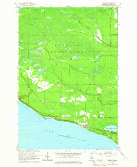 1964 Brevort1965 Print · USGSThe Mackinac coast of the Upper Peninsula comes into focus during the mid-1960s, showing the intersection of Great Lakes shoreline and managed forest. Researchers can trace the layout of the Brevort settlement, the Brevort Cem, and recreational sites like the Little Brevoort Lake Campground.2 unique versions available
 - 1964 Map of Epoufette, 1966 Print
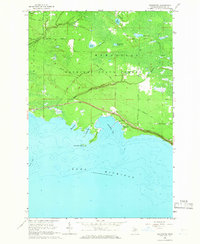 1964 Epoufette1966 Print · USGSThe Upper Peninsula shoreline near Epoufette in the mid-1960s reveals a landscape of secluded harbors and deep forest tracks. Researchers can trace local heritage at the Epoufette Cem or follow historic paths like the Old Stage Trail and Hiawatha Trail.2 unique versions available
 - 1964 Map of Rexton, 1966 Print
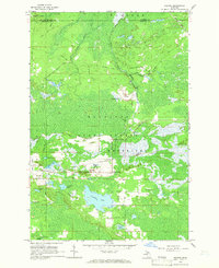 1964 Rexton1966 Print · USGSThe Upper Peninsula’s timber and mining heritage is on display in this mid-century survey of Mackinac County. Researchers can trace the legacy of the Fiborn Quarry and the Soo Line railroad near Rexton and the Caffey Cem.2 unique versions available
 - 1964 Map of Trout Lake, 1966 Print
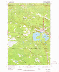 1964 Trout Lake1966 Print · USGSTrout Lake emerged as a vital Upper Peninsula rail hub in the mid-twentieth century, surrounded by the deep woods of the Hiawatha and Mackinac State Forests. Researchers can trace the original Soo Line rail corridors, the historic Lakeview Cem, and local landmarks like School No 15.2 unique versions available
End of results
Showing maps 1-4 of 4
Top cities near Hendricks Township
Top neighborhoods of Hendricks Township
- Cut River historical maps
- Epoufette historical maps
- Caffey historical maps
- Caffey Corner historical maps
Frequently asked questions
- What are the different types of historical maps available for Hendricks Township?
- What is the oldest map of Hendricks Township?
- Where can I purchase historical maps of Hendricks Township for my home or office?
- Where can I download high-res historical maps of Hendricks Township?
- Are there historical topographic maps available for Hendricks Township?
- Is there historical aerial imagery available for Hendricks Township?
- Where are historical maps of Hendricks Township sourced from?