1930s Maps of Hendricks Township, Michigan
Explore 4 historic maps of Hendricks Township from the 1930s. These maps offer a rare glimpse into what life looked like during the 1930s — showing old roads, neighborhoods, homes, and landmarks that have changed or disappeared over time.
Whether you're researching your family's past, planning a metal detecting trip, or studying how Hendricks Township's landscape evolved across the 1930s, these high-resolution maps are a powerful tool for exploring the history of this region.
- Focus on a specific era: All maps on this page are from the 1930s, giving you a focused view of this time period.
- See what’s changed: Compare century-old streets, trails, and buildings to today's modern landscape using overlays and satellite layers.
- Research with precision: Use these maps for genealogy, historical research, land use analysis, or educational projects.
- View, download, or print: Maps are fully viewable online in high resolution, and can be downloaded or printed for your own records.
Start exploring Hendricks Township's history through authentic maps from the 1930s. This is your window into the past.
Hendricks Township, MI maps
(4)- 1931 Map of Epoufette SE
 1931 Epoufette SE1931 Print · USGSThe Mackinac County shoreline appears in the early 1930s as a quiet stretch of coastal wetlands and new highway development. Researchers can trace early settlements like Manitou Payment and Brevoort along the banks of Little Brevoort Lake and the Brevoort River.
 - 1931 Map of Epoufette NE
 1931 Epoufette NE1931 Print · USGSUpper Peninsula timber and rail corridors come alive in this early 1930s survey of the Chippewa and Mackinac county line. Genealogy and transit researchers can trace the tracks of the Duluth South Shore and Atlantic near Wilwin and the waters of Trout Lake.
 - 1931 Map of Epoufette NW
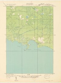
 1931 Epoufette NW1931 Print · USGSMackinac County's industrial and rail corridor is captured here in the early thirties as stone and timber drove the local economy. Genealogists and historians can trace the foundations of Rexton, Caffey, and the extensive works at Fiborn Quarry.
 - 1931 Map of Epoufette SW
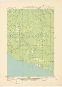
 1931 Epoufette SW1931 Print · USGSThe Mackinac coast of the Upper Peninsula is captured in the early 1930s as a quiet network of shoreline settlements and inland creeks. Researchers can trace the layout of the village at Epoufette, locate the local Cem, and follow the route of U S Highway No 2.
End of results
Showing maps 1-4 of 4
Top cities near Hendricks Township
Top neighborhoods of Hendricks Township
- Cut River historical maps
- Epoufette historical maps
- Caffey historical maps
- Caffey Corner historical maps
Frequently asked questions
- What are the different types of historical maps available for Hendricks Township?
- What is the oldest map of Hendricks Township?
- Where can I purchase historical maps of Hendricks Township for my home or office?
- Where can I download high-res historical maps of Hendricks Township?
- Are there historical topographic maps available for Hendricks Township?
- Is there historical aerial imagery available for Hendricks Township?
- Where are historical maps of Hendricks Township sourced from?