1930s Maps of Saint Ignace Township, Michigan
Explore 4 historic maps of Saint Ignace Township from the 1930s. These maps offer a rare glimpse into what life looked like during the 1930s — showing old roads, neighborhoods, homes, and landmarks that have changed or disappeared over time.
Whether you're researching your family's past, planning a metal detecting trip, or studying how Saint Ignace Township's landscape evolved across the 1930s, these high-resolution maps are a powerful tool for exploring the history of this region.
- Focus on a specific era: All maps on this page are from the 1930s, giving you a focused view of this time period.
- See what’s changed: Compare century-old streets, trails, and buildings to today's modern landscape using overlays and satellite layers.
- Research with precision: Use these maps for genealogy, historical research, land use analysis, or educational projects.
- View, download, or print: Maps are fully viewable online in high resolution, and can be downloaded or printed for your own records.
Start exploring Saint Ignace Township's history through authentic maps from the 1930s. This is your window into the past.
Saint Ignace Township, MI maps
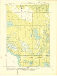
(4)- 1931 Map of St Ignace NW
 1931 St Ignace NW1931 Print · USGSMackinac County's shoreline and offshore islands are captured here in the early 1930s, showing the region's rural character before modern expansion. Genealogists and local historians can locate early landmarks like Fort Algonquin, Rabbits Back Sch, and the docks at British Landing.
 - 1931 Map of Moran NE
 1931 Moran NE1931 Print · USGSUpper Peninsula life in the 1930s centered on the rail-and-road corridor between the Lake Michigan shore and the inland forests. Researchers can trace family history through St Marys Cem or locate the Christensen Resort and the tracks of the Duluth South Shore and Atlantic.
 - 1931 Map of Ozark SE
 1931 Ozark SE1931 Print · USGSThe marshlands of Mackinac and Chippewa counties are documented here in the early 1930s just as aerial surveying began to refine our understanding of the Upper Peninsula. Researchers can trace the path of the Duluth South Shore and Atlantic rail line and locate the small settlement at Maple Hill near East Lake.2 unique versions available
 - 1932 Map of St Ignace NE
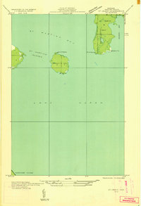 1932 St Ignace NE1932 Print · USGSThe waters of northern Lake Huron and the isolated St Martins Islands are captured here in the early 1930s. Genealogists and maritime historians can trace the early survey of Marquette Point and the coastal boundaries of Marquette Twp.
End of results
Showing maps 1-4 of 4
Top cities near Saint Ignace Township
- Saint Ignace historical maps
- Rudyard historical maps
- Moran historical maps
- Mackinac Island historical maps
Top neighborhoods of Saint Ignace Township
Frequently asked questions
- What are the different types of historical maps available for Saint Ignace Township?
- What is the oldest map of Saint Ignace Township?
- Where can I purchase historical maps of Saint Ignace Township for my home or office?
- Where can I download high-res historical maps of Saint Ignace Township?
- Are there historical topographic maps available for Saint Ignace Township?
- Is there historical aerial imagery available for Saint Ignace Township?
- Where are historical maps of Saint Ignace Township sourced from?