1910s Maps of Washington Charter Township, Michigan
Explore 2 historic maps of Washington Charter Township from the 1910s. These maps offer a rare glimpse into what life looked like during the 1910s — showing old roads, neighborhoods, homes, and landmarks that have changed or disappeared over time.
Whether you're researching your family's past, planning a metal detecting trip, or studying how Washington Charter Township's landscape evolved across the 1910s, these high-resolution maps are a powerful tool for exploring the history of this region.
- Focus on a specific era: All maps on this page are from the 1910s, giving you a focused view of this time period.
- See what’s changed: Compare century-old streets, trails, and buildings to today's modern landscape using overlays and satellite layers.
- Research with precision: Use these maps for genealogy, historical research, land use analysis, or educational projects.
- View, download, or print: Maps are fully viewable online in high resolution, and can be downloaded or printed for your own records.
Start exploring Washington Charter Township's history through authentic maps from the 1910s. This is your window into the past.
Washington Charter Township, MI maps
(2)- 1912 Map of Mt Clemens
 1912 Mt Clemens1912 Print · USGSMacomb County at the dawn of the aviation age shows a landscape shaped by the winding Clinton River and the arrival of Selfridge Aviation Field. Genealogists and historians can locate legacy settlements like Waldenburg and early industrial sites like the Macomb Sugar Factory.
 - 1914 Map of Armada
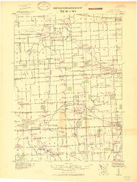 1914 Armada1914 Print · USGSMacomb and St. Clair Counties are seen here in the years before the Great War as a productive agricultural landscape tied together by rail. Researchers can trace historic farmstead locations and early rural infrastructure, from Wolcotts Mill Pond to the busy Grand Trunk R. R. junctions at Armada and Richmond.
End of results
Showing maps 1-2 of 2
Top cities near Washington Charter Township
- Sterling Heights historical maps
- Warren historical maps
- Clinton Township historical maps
- Macomb Township historical maps
- Troy historical maps
- Shelby Charter Township historical maps
See more
Top neighborhoods of Washington Charter Township
- Clifton Mill historical maps
- Mount Vernon historical maps
- Copperwood Commons historical maps
- The Villas at Copperwood historical maps
- The Enclave historical maps
- Hidden Oak historical maps
See more
Frequently asked questions
- What are the different types of historical maps available for Washington Charter Township?
- What is the oldest map of Washington Charter Township?
- Where can I purchase historical maps of Washington Charter Township for my home or office?
- Where can I download high-res historical maps of Washington Charter Township?
- Are there historical topographic maps available for Washington Charter Township?
- Is there historical aerial imagery available for Washington Charter Township?
- Where are historical maps of Washington Charter Township sourced from?