1950s Maps of Chocolay Township, Michigan
Explore 6 historic maps of Chocolay Township from the 1950s. These maps offer a rare glimpse into what life looked like during the 1950s — showing old roads, neighborhoods, homes, and landmarks that have changed or disappeared over time.
Whether you're researching your family's past, planning a metal detecting trip, or studying how Chocolay Township's landscape evolved across the 1950s, these high-resolution maps are a powerful tool for exploring the history of this region.
- Focus on a specific era: All maps on this page are from the 1950s, giving you a focused view of this time period.
- See what’s changed: Compare century-old streets, trails, and buildings to today's modern landscape using overlays and satellite layers.
- Research with precision: Use these maps for genealogy, historical research, land use analysis, or educational projects.
- View, download, or print: Maps are fully viewable online in high resolution, and can be downloaded or printed for your own records.
Start exploring Chocolay Township's history through authentic maps from the 1950s. This is your window into the past.
Chocolay Township, MI maps
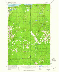
(6)- 1950 Map of Skandia NW
 1950 Skandia NW1950 Print · USGSThe Marquette County shoreline and timberlands come into focus at mid-century, where rail lines and river forks meet. Genealogists and historians can trace the foundations of Yalmer and New Dalton through the Yalmer Sch and Skandia Cem.
 - 1952 Map of Gwinn, 1954 Print
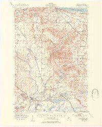 1952 Gwinn1954 Print · USGSMarquette County's iron country and the Lake Superior shoreline are captured here in the early fifties during a period of industrial transition. Genealogists and industrial historians can trace the inactive Stephenson Mine, the Little Lake (Forsyth P O) settlement, and rural schools like June Sch.5 unique versions available
 - 1954 Map of Marquette, 1959 Print
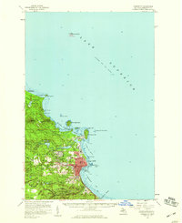 1954 Marquette1959 Print · USGSMarquette's harbor and lakeside settlement are shown in detail during the mid-fifties, when the city was a center of regional education and industry. Genealogists and historians can trace the foundations of Northern Michigan College or locate family sites near Park Cemetery and Brookton Corners.
 - 1958 Map of Laughing Fish Point, 1959 Print
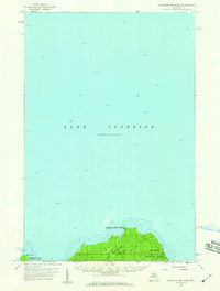 1958 Laughing Fish Point1959 Print · USGSThe Lake Superior shoreline in the late fifties is defined here by its maritime hazards and vast forest boundaries. Researchers can trace the exact topography of Laughing Fish Point and the mouth of the Laughing Whitefish River within the Hiawatha National Forest.2 unique versions available
 - 1958 Map of Skandia, 1959 Print
 1958 Skandia1959 Print · USGSThe Lake Superior coast and Michigan's Upper Peninsula timberlands are captured here in the late fifties. Genealogists and local historians can trace family roots at Skandia Cem and Deerton Cem or locate the old Yalmer Station along the historic rail lines.2 unique versions available
 - 1958 Map of Marquette, 1968 Print
 1958 Marquette1968 Print · USGSThe Upper Peninsula’s central corridor is captured here in the mid-twentieth century as mining and timber industries thrived alongside new military installations. Genealogists and historians can trace the rail lines of the Soo Line Railroad through settlements like Gwinn, Turin, and Chatham.2 unique versions available
End of results
Showing maps 1-6 of 6
Top cities near Chocolay Township
- Marquette historical maps
- Sands historical maps
- Gwinn historical maps
- Trowbridge Park historical maps
- Skandia historical maps
Top neighborhoods of Chocolay Township
- Gordon historical maps
- Green Garden historical maps
- Beaver Grove historical maps
- Mangum historical maps
- Harvey historical maps
- Lakewood historical maps
Frequently asked questions
- What are the different types of historical maps available for Chocolay Township?
- What is the oldest map of Chocolay Township?
- Where can I purchase historical maps of Chocolay Township for my home or office?
- Where can I download high-res historical maps of Chocolay Township?
- Are there historical topographic maps available for Chocolay Township?
- Is there historical aerial imagery available for Chocolay Township?
- Where are historical maps of Chocolay Township sourced from?