1980s Maps of Chocolay Township, Michigan
Explore 6 historic maps of Chocolay Township from the 1980s. These maps offer a rare glimpse into what life looked like during the 1980s — showing old roads, neighborhoods, homes, and landmarks that have changed or disappeared over time.
Whether you're researching your family's past, planning a metal detecting trip, or studying how Chocolay Township's landscape evolved across the 1980s, these high-resolution maps are a powerful tool for exploring the history of this region.
- Focus on a specific era: All maps on this page are from the 1980s, giving you a focused view of this time period.
- See what’s changed: Compare century-old streets, trails, and buildings to today's modern landscape using overlays and satellite layers.
- Research with precision: Use these maps for genealogy, historical research, land use analysis, or educational projects.
- View, download, or print: Maps are fully viewable online in high resolution, and can be downloaded or printed for your own records.
Start exploring Chocolay Township's history through authentic maps from the 1980s. This is your window into the past.
Chocolay Township, MI maps
(6)- 1983 Map of Gwinn
 1983 Gwinn1983 Print · USGSThe heart of Michigan's Marquette Iron Range is captured here during the 1980s, when mining and military operations defined the local landscape. Genealogists and industrial historians can trace the tracks of the Chicago and North Western to the National Mine or the airman's life at K I Sawyer Air Force Base.2 unique versions available
 - 1985 Map of Harvey
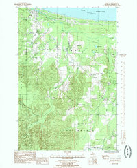 1985 Harvey1985 Print · USGSThe Lake Superior coast and the winding Chocolay River south of Marquette appear here in the early eighties. Researchers can trace rural community life through landmarks like St Pauls Cem, the Mangum Prison Farm, and the Fish Hatchery.
 - 1985 Map of Sand River
 1985 Sand River1985 Print · USGSThe Lake Superior coast and Michigan's North Woods come alive in the mid-eighties as rail and river networks intersect. Researchers can locate the Deerton Cem, trace the Soo Line tracks, or follow the path to the Laughing Whitefish Falls.
 - 1985 Map of Skandia
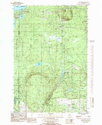
 1985 Skandia1985 Print · USGSThe Upper Peninsula shoreline and interior forests near Marquette come into focus in the mid-eighties. Genealogists and historians can trace family-named roads and sites like Haglund Cem, Yalmar Station, and the Old Railroad Grade.
 - 1985 Map of Shot Point
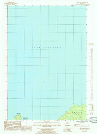 1985 Shot Point1985 Print · USGSThe Lake Superior shoreline in the mid-1980s reveals the coastal transition between Marquette and Alger counties. Researchers can trace the exact shoreline topography around Shot Point and the township boundaries near Onota.
 - 1985 Map of Marquette
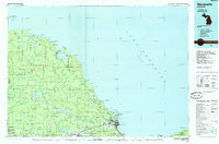 1985 Marquette1985 Print · USGSThe iron mining country of Michigan's Upper Peninsula is shown here during the mid-1980s as industrial transport networks connected the interior to the coast. Researchers can trace historic rail lines like the Soo Line and Ls&I or locate local landmarks like Holy Cross Cem and Northern Michigan University.3 unique versions available
End of results
Showing maps 1-6 of 6
Top cities near Chocolay Township
- Marquette historical maps
- Sands historical maps
- Gwinn historical maps
- Trowbridge Park historical maps
- Skandia historical maps
Top neighborhoods of Chocolay Township
- Gordon historical maps
- Green Garden historical maps
- Beaver Grove historical maps
- Mangum historical maps
- Harvey historical maps
- Lakewood historical maps
Frequently asked questions
- What are the different types of historical maps available for Chocolay Township?
- What is the oldest map of Chocolay Township?
- Where can I purchase historical maps of Chocolay Township for my home or office?
- Where can I download high-res historical maps of Chocolay Township?
- Are there historical topographic maps available for Chocolay Township?
- Is there historical aerial imagery available for Chocolay Township?
- Where are historical maps of Chocolay Township sourced from?