1940s Maps of Memphis, Michigan
Explore 1 historic maps of Memphis from the 1940s. These maps offer a rare glimpse into what life looked like during the 1940s — showing old roads, neighborhoods, homes, and landmarks that have changed or disappeared over time.
Whether you're researching your family's past, planning a metal detecting trip, or studying how Memphis's landscape evolved across the 1940s, these high-resolution maps are a powerful tool for exploring the history of this region.
- Focus on a specific era: All maps on this page are from the 1940s, giving you a focused view of this time period.
- See what’s changed: Compare century-old streets, trails, and buildings to today's modern landscape using overlays and satellite layers.
- Research with precision: Use these maps for genealogy, historical research, land use analysis, or educational projects.
- View, download, or print: Maps are fully viewable online in high resolution, and can be downloaded or printed for your own records.
Start exploring Memphis's history through authentic maps from the 1940s. This is your window into the past.
Memphis, MI maps
(1)- 1944 Map of Memphis
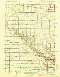 1944 Memphis1944 Print · USGSSoutheast Michigan farm country is documented here in the 1940s, showing the early crossroads and river-bound settlements of St. Clair and Macomb counties. Genealogists can locate family landmarks like Pound Hill Sch, the village of Riley Center, and the Grand Trunk Western rail line.2 unique versions available
End of results
Showing maps 1-1 of 1
Top cities near Memphis
- Macomb Township historical maps
- Shelby Charter Township historical maps
- Chesterfield Township historical maps
- Washington Charter Township historical maps
- New Baltimore historical maps
- Kimball historical maps
See more
Frequently asked questions
- What are the different types of historical maps available for Memphis?
- What is the oldest map of Memphis?
- Where can I purchase historical maps of Memphis for my home or office?
- Where can I download high-res historical maps of Memphis?
- Are there historical topographic maps available for Memphis?
- Is there historical aerial imagery available for Memphis?
- Where are historical maps of Memphis sourced from?