1980s Maps of Montmorency County, Michigan
Explore 17 historic maps of Montmorency County from the 1980s. These maps offer a rare glimpse into what life looked like during the 1980s — showing old roads, neighborhoods, homes, and landmarks that have changed or disappeared over time.
Whether you're researching your family's past, planning a metal detecting trip, or studying how Montmorency County's landscape evolved across the 1980s, these high-resolution maps are a powerful tool for exploring the history of this region.
- Focus on a specific era: All maps on this page are from the 1980s, giving you a focused view of this time period.
- See what’s changed: Compare century-old streets, trails, and buildings to today's modern landscape using overlays and satellite layers.
- Research with precision: Use these maps for genealogy, historical research, land use analysis, or educational projects.
- View, download, or print: Maps are fully viewable online in high resolution, and can be downloaded or printed for your own records.
Start exploring Montmorency County's history through authentic maps from the 1980s. This is your window into the past.
Montmorency County, MI maps
(17)- 1982 Map of Petoskey
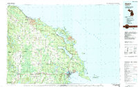
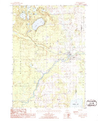
 1982 Petoskey1982 Print · USGSNorthern Michigan in the early eighties shows a landscape of deep timber and vast inland lakes. Genealogists and historians can trace the rail corridors of the Michigan Central and Detroit and Mackinac between Petoskey, Gaylord, and Wolverine.
 - 1983 Map of Hubbard Lake, 1984 Print
 1983 Hubbard Lake1984 Print · USGSThe shorelines of Alcona and Alpena Counties come to life in this early 1980s overview of the Lake Huron coast and its deep timberlands. Researchers can trace historic rail routes like the Detroit and Mackinac or locate quiet inland hubs such as Barton City and Killmaster.
 - 1983 Map of Grayling, 1984 Print
 1983 Grayling1984 Print · USGSIn the early eighties, this Northern Michigan interior was a hub for forestry, military training, and river recreation. Researchers can trace the sprawling boundaries of Camp Grayling and locate historic markers like Hartwick Pines and Otsego Lake.2 unique versions available
 - 1984 Map of Alpena
 1984 Alpena1984 Print · USGSThe Lake Huron shoreline in the 1980s reveals a region defined by maritime industry, timberlands, and vast inland waters. Genealogists and historians can trace the Detroit and Mackinac Railroad past old settlements like Posen, Hagensville, and the harbor at Rockport.
 - 1986 Map of Silver Lake
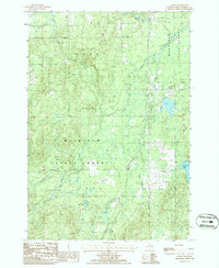
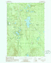
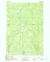 1986 Silver Lake1986 Print · USGSThe dense forests of Northern Michigan come alive in this mid-eighties survey of the tri-county border between Cheboygan, Otsego, and Montmorency. Trace the legacy of timber and transit along the Old Railroad Grade or explore the waters of Silver Lake and the Foch Lakes Flooding.2 unique versions available
 - 1986 Map of Atlanta SE
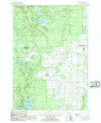
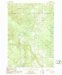
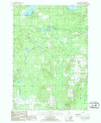 1986 Atlanta SE1986 Print · USGSMontmorency County’s forested interior is captured in the mid-1980s, showcasing a landscape of timber and hidden waters. Researchers can locate an Old RR Grade and a remote Landing Strip near the shores of Lake Hiawatha and Rush Lake.
 - 1986 Map of Crooked Lake
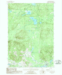
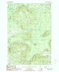
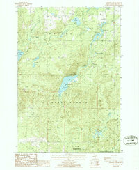 1986 Crooked Lake1986 Print · USGSNorthern Michigan’s glacial lake country is captured here during the mid-1980s, centered on the protected lands of the Mackinaw State Forest. Researchers can trace the waterways of the Thunder Bay River and locate seasonal sites like the Avery Lake campground and Hunt Creek Fisheries Research Area.2 unique versions available
 - 1986 Map of Avery
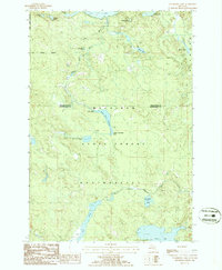
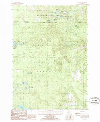
 1986 Avery1986 Print · USGSMontmorency County was a landscape of timber and trout streams in the 1980s, shaped by the logging history of the Mackinaw State Forest. Researchers can trace the Old Railroad Grade past Avery and locate family landmarks along Gilchrist Creek or near Lockwood Lake.
 - 1986 Map of Royston
 1986 Royston1986 Print · USGSMontmorency County and the Mackinaw State Forest are shown here in the mid-1980s, revealing a landscape of dense timber and glacial lakes. Genealogists and local historians can trace the early Old Railroad Grade and find family sites near Royston or the Cem in Wellington.
 - 1986 Map of Atlanta
 1986 Atlanta1986 Print · USGSMontmorency County in the mid-1980s reveals a landscape defined by state forestry and winding glacial waterways. Genealogists and historians can trace the Old RR Grade through the Green Swamp or locate family landmarks near Atlanta and Big Rock.
 - 1986 Map of Cranberry Lake
 1986 Cranberry Lake1986 Print · USGSMontmorency and Presque Isle counties are captured in the mid-1980s as a densely forested lake district within the Mackinaw State Forest. Researchers can trace the water flow from the Rainy River Dam through the Rainy River Flooding and locate remote features like the northern Landing Strip (Pvt).
 - 1986 Map of Hillman
 1986 Hillman1986 Print · USGSHillman and the surrounding lake country of Montmorency County are captured here in the mid-1980s. Local researchers can trace the course of the Thunder Bay River and locate historic sites like the Cem, Gravel Pits, and Fletcher Pond.
 - 1986 Map of Lake Geneva
 1986 Lake Geneva1986 Print · USGSMontmorency County and the surrounding state forest lands are shown here in the mid-eighties as a pristine network of glacial lakes and managed timber. You can trace the boundaries of Canada Creek Ranch or locate campsites at Clear Lake State Park and Shoepac Lake.
 - 1986 Map of Hetherton
 1986 Hetherton1986 Print · USGSMontmorency County during the mid-eighties remains a landscape of deep woods and historic timber paths within the Mackinaw State Forest. Researchers can trace the heritage of the timber era via the Old Railroad Grade or locate family landmarks near Hetherton and Gingell Lake.
 - 1986 Map of Oak Lake
 1986 Oak Lake1986 Print · USGSThe Oscoda and Montmorency county line in the mid-eighties was a landscape of conservation and legacy timber infrastructure. You can trace the path of an Old RR Grade through the Au Sable State Forest or explore the specialized waters of the Fisheries Research Area.
 - 1986 Map of Comins
 1986 Comins1986 Print · USGSOscoda and Montmorency Counties are depicted in the mid-1980s as a managed wilderness of state and national forests. Researchers can trace the legacy of regional transit along an old Railroad Grade and locate local landmarks like the Cem and Comins Marsh.
 - 1989 Map of Traverse City, 1990 Print
 1989 Traverse City1990 Print · USGSNorthern Michigan’s lake-country and forest lands are captured in the late eighties as seasonal tourism and timber hubs expanded. Genealogists and historians can trace the routes of the Ann Arbor RR, the boundaries of Camp Grayling, and settlements like Elk Rapids and Manton.
End of results
Showing maps 1-17 of 17
Frequently asked questions
- What are the different types of historical maps available for Montmorency County?
- What is the oldest map of Montmorency County?
- Where can I purchase historical maps of Montmorency County for my home or office?
- Where can I download high-res historical maps of Montmorency County?
- Are there historical topographic maps available for Montmorency County?
- Is there historical aerial imagery available for Montmorency County?
- Where are historical maps of Montmorency County sourced from?