1970s Maps of Rust Township, Michigan
Explore 2 historic maps of Rust Township from the 1970s. These maps offer a rare glimpse into what life looked like during the 1970s — showing old roads, neighborhoods, homes, and landmarks that have changed or disappeared over time.
Whether you're researching your family's past, planning a metal detecting trip, or studying how Rust Township's landscape evolved across the 1970s, these high-resolution maps are a powerful tool for exploring the history of this region.
- Focus on a specific era: All maps on this page are from the 1970s, giving you a focused view of this time period.
- See what’s changed: Compare century-old streets, trails, and buildings to today's modern landscape using overlays and satellite layers.
- Research with precision: Use these maps for genealogy, historical research, land use analysis, or educational projects.
- View, download, or print: Maps are fully viewable online in high resolution, and can be downloaded or printed for your own records.
Start exploring Rust Township's history through authentic maps from the 1970s. This is your window into the past.
Rust Township, MI maps
(2)- 1972 Map of McCollum Lake, 1975 Print
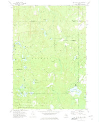 1972 McCollum Lake1975 Print · USGSNorthern Michigan forest lands are shown in the early seventies at the junction of four counties. Researchers can trace old logging routes along the Old Railroad Grade and locate features like McCollum Lake and the Fonro Lodge Landing Strip.
 - 1972 Map of Rust, 1975 Print
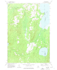 1972 Rust1975 Print · USGSMontmorency County in the early seventies is shown here as a dense network of state forests and winding waterways. Local historians can trace the Old Railroad Grade near Rust or locate family landmarks like the Rust Sch and the Turtle Lake Club Airport.
End of results
Showing maps 1-2 of 2
Top cities near Rust Township
Top neighborhoods of Rust Township
Frequently asked questions
- What are the different types of historical maps available for Rust Township?
- What is the oldest map of Rust Township?
- Where can I purchase historical maps of Rust Township for my home or office?
- Where can I download high-res historical maps of Rust Township?
- Are there historical topographic maps available for Rust Township?
- Is there historical aerial imagery available for Rust Township?
- Where are historical maps of Rust Township sourced from?