1980s Maps of Goodwell Township, Michigan
Explore 5 historic maps of Goodwell Township from the 1980s. These maps offer a rare glimpse into what life looked like during the 1980s — showing old roads, neighborhoods, homes, and landmarks that have changed or disappeared over time.
Whether you're researching your family's past, planning a metal detecting trip, or studying how Goodwell Township's landscape evolved across the 1980s, these high-resolution maps are a powerful tool for exploring the history of this region.
- Focus on a specific era: All maps on this page are from the 1980s, giving you a focused view of this time period.
- See what’s changed: Compare century-old streets, trails, and buildings to today's modern landscape using overlays and satellite layers.
- Research with precision: Use these maps for genealogy, historical research, land use analysis, or educational projects.
- View, download, or print: Maps are fully viewable online in high resolution, and can be downloaded or printed for your own records.
Start exploring Goodwell Township's history through authentic maps from the 1980s. This is your window into the past.
Goodwell Township, MI maps
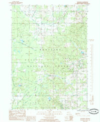
(5)- 1984 Map of Big Rapids
 1984 Big Rapids1984 Print · USGSMid-Michigan in the mid-eighties shows a balance of deep-woods conservation and riverfront industry centered on the Muskegon River. Genealogists and historians can trace rail-town development along the Chesapeake and Ohio or locate family sites near Idlewild, Reed City, and Forest Hill Cem.
 - 1985 Map of Woodville
 1985 Woodville1985 Print · USGSNewaygo County's forested interior is captured here in the mid-1980s, showcasing the intersection of the timber industry and protected lands. Researchers can trace the Old Railroad Grade or locate historic industry sites like the Gas Field near Woodville.
 - 1985 Map of Big Prairie
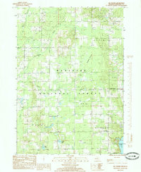 1985 Big Prairie1985 Print · USGSNewaygo County's sandy plains and forest lands are captured in the mid-eighties as modern recreation and old industries began to overlap. Researchers can trace the Old Grade, locate family plots at the Cem, or explore the shores of Hardy Dam Pond and Eaves Lake.
 - 1985 Map of Big Bend
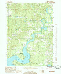 1985 Big Bend1985 Print · USGSThe Muskegon River oxbow and the upper reaches of Hardy Dam Pond define this 1980s landscape along the Newaygo and Mecosta county line. Local historians and genealogists can trace lakeside landmarks like Brower Park and the small settlement of Bennett.
 - 1985 Map of Woodville NE
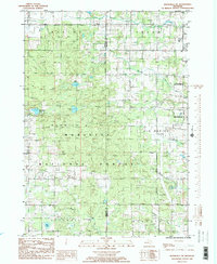 1985 Woodville NE1985 Print · USGSThe border of Newaygo and Mecosta Counties is captured here in the mid-1980s as the Manistee National Forest meets the expansion of Big Rapids. Genealogists and local historians can locate the Cem, trace family-named creeks like Betts Creek, and find mid-century landmarks like the Drive-In Theater.2 unique versions available
End of results
Showing maps 1-5 of 5
Top cities near Goodwell Township
- Big Rapids historical maps
- Croton historical maps
- Big Prairie historical maps
- Newaygo historical maps
- Howard City historical maps
- White Cloud historical maps
See more
Frequently asked questions
- What are the different types of historical maps available for Goodwell Township?
- What is the oldest map of Goodwell Township?
- Where can I purchase historical maps of Goodwell Township for my home or office?
- Where can I download high-res historical maps of Goodwell Township?
- Are there historical topographic maps available for Goodwell Township?
- Is there historical aerial imagery available for Goodwell Township?
- Where are historical maps of Goodwell Township sourced from?