1980s Maps of Home Township, Michigan
Explore 5 historic maps of Home Township from the 1980s. These maps offer a rare glimpse into what life looked like during the 1980s — showing old roads, neighborhoods, homes, and landmarks that have changed or disappeared over time.
Whether you're researching your family's past, planning a metal detecting trip, or studying how Home Township's landscape evolved across the 1980s, these high-resolution maps are a powerful tool for exploring the history of this region.
- Focus on a specific era: All maps on this page are from the 1980s, giving you a focused view of this time period.
- See what’s changed: Compare century-old streets, trails, and buildings to today's modern landscape using overlays and satellite layers.
- Research with precision: Use these maps for genealogy, historical research, land use analysis, or educational projects.
- View, download, or print: Maps are fully viewable online in high resolution, and can be downloaded or printed for your own records.
Start exploring Home Township's history through authentic maps from the 1980s. This is your window into the past.
Home Township, MI maps
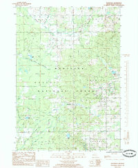
(5)- 1984 Map of Big Rapids
 1984 Big Rapids1984 Print · USGSMid-Michigan in the mid-eighties shows a balance of deep-woods conservation and riverfront industry centered on the Muskegon River. Genealogists and historians can trace rail-town development along the Chesapeake and Ohio or locate family sites near Idlewild, Reed City, and Forest Hill Cem.
 - 1985 Map of Woodville
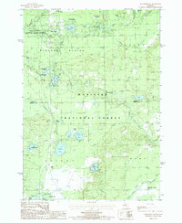
 1985 Woodville1985 Print · USGSNewaygo County's forested interior is captured here in the mid-1980s, showcasing the intersection of the timber industry and protected lands. Researchers can trace the Old Railroad Grade or locate historic industry sites like the Gas Field near Woodville.
 - 1985 Map of Woodland Park
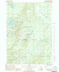 1985 Woodland Park1985 Print · USGSNewaygo County is shown in the mid-1980s as a land of quiet forest settlements and dense lake clusters. Researchers can trace the layout of Woodland Park, Bitely, and Brohman or locate numerous water bodies like Loda Lake and Woodland Lake.2 unique versions available
 - 1987 Map of Marlborough
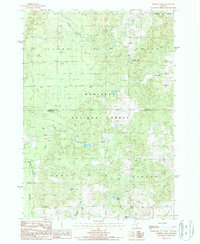
 1987 Marlborough1987 Print · USGSThe Lake and Newaygo County borderlands are shown here in the late eighties, an era defined by glacial lakes and timberlands. Researchers can trace the Old RR Grade and locate local landmarks like the Drive-In Theater and Pettibone Lake.
 - 1987 Map of Whipple Lake
 1987 Whipple Lake1987 Print · USGSThe Lake and Newaygo County line in the late 1980s was a landscape of dense forest and glacial lakes. Local historians can trace the paths of the Middle Branch Pere Marquette River and locate secluded sites like Whipple Lake and a small rural Cem.
End of results
Showing maps 1-5 of 5
Top cities near Home Township
- Reed City historical maps
- White Cloud historical maps
- Chase historical maps
- Baldwin historical maps
- Lilley historical maps
Frequently asked questions
- What are the different types of historical maps available for Home Township?
- What is the oldest map of Home Township?
- Where can I purchase historical maps of Home Township for my home or office?
- Where can I download high-res historical maps of Home Township?
- Are there historical topographic maps available for Home Township?
- Is there historical aerial imagery available for Home Township?
- Where are historical maps of Home Township sourced from?