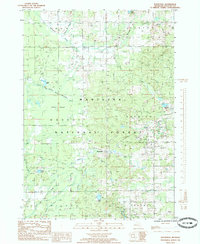
1985 Map of Woodville
USGS Topo · Published 1985About this map
The Manistee National Forest dominates this mid-1980s landscape, where the small settlement of Woodville serves as a central point in a region defined by its timber and water resources. The terrain is crisscrossed by several waterways, most notably the Little South Branch Pere Marquette River and the South White River, which drain through the Oxford Swamp. This environment supported various industries, evidenced by the presence of a Gas Field, Oil Tanks, and a Gravel Pit scattered across the township boundaries of Monroe and Norwich.
Find a feature on this map
31 named features on this map. Tap any name to fly to it.
Don’t see what you’re looking for? This feature index may not catch every label — zoom into the map to look around manually.
Map Details
Editions of this 1985 Woodville Map
This is the sole edition of this map. No revisions or reprints were ever made.
Other maps of this area

1954 · Midland
USGS Topo · 1:250,000

1958 · Midland
USGS Topo · 1:250,000

1958 · Woodville
USGS Topo · 1:62,500

1959 · Midland
USGS Topo · 1:250,000

1959 · Reed City
USGS Topo · 1:62,500

1959 · Baldwin
USGS Topo · 1:62,500

1959 · White Cloud
USGS Topo · 1:62,500

1966 · Midland
USGS Topo · 1:250,000
1976 · Baldwin SE
USGS Topo · 1:24,000

1976 · White Cloud SE
USGS Topo · 1:24,000
Featured Places
- Goodwell Township, MI
- Monroe Township, MI
- Norwich Township, MI
- Woodville, Norwich Township
- Barton Township, MI