
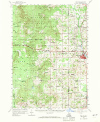
1959 Map of Reed City
USGS Topo · Published 1960About this map
Reed City serves as the primary hub of this west-central Michigan landscape, where the Pennsylvania railroad corridor meets the east-west tracks of the Chesapeake And Ohio. This intersection defines the local economy, supporting outlying settlements like Ashton, Nirvana, and Paris. The terrain is defined by a dense network of country schools such as Maple Hill Sch and Spears Grove Sch, reflecting the distributed nature of rural Michigan education in the mid-20th century. Extensive public lands including the Pere Marquette State Forest and Manistee National Forest cover the western half of the quadrangle, punctuated by fire watch infrastructure like the Yates Lookout Tower and Pinora Lookout Tower. The survey also documents the area's aquatic resources, from the Fish Hatchery near Paris to the numerous small lakes and ponds, including Totten Lake and Bristol Pond, that feed into the Middle Branch Pere Marquette River.
Find a feature on this map
87 named features on this map. Tap any name to fly to it.
Don’t see what you’re looking for? This feature index may not catch every label — zoom into the map to look around manually.
Map Details
Editions of this 1959 Reed City Map
2 editions found
Other maps of this area

1931 · Chase NE
USGS Topo · 1:31,680

1931 · Baldwin NE
USGS Topo · 1:31,680

1932 · Chase NW
USGS Topo · 1:31,680

1933 · Peacock SE
USGS Topo · 1:31,680

1933 · Luther SE
USGS Topo · 1:31,680

1933 · Luther SW
USGS Topo · 1:31,680

1954 · Traverse City
USGS Topo · 1:250,000

1954 · Midland
USGS Topo · 1:250,000

1957 · Cadillac South
USGS Topo · 1:62,500

1957 · Luther
USGS Topo · 1:62,500