1990s Maps of Orion Charter Township, Michigan
Explore 5 historic maps of Orion Charter Township from the 1990s. These maps offer a rare glimpse into what life looked like during the 1990s — showing old roads, neighborhoods, homes, and landmarks that have changed or disappeared over time.
Whether you're researching your family's past, planning a metal detecting trip, or studying how Orion Charter Township's landscape evolved across the 1990s, these high-resolution maps are a powerful tool for exploring the history of this region.
- Focus on a specific era: All maps on this page are from the 1990s, giving you a focused view of this time period.
- See what’s changed: Compare century-old streets, trails, and buildings to today's modern landscape using overlays and satellite layers.
- Research with precision: Use these maps for genealogy, historical research, land use analysis, or educational projects.
- View, download, or print: Maps are fully viewable online in high resolution, and can be downloaded or printed for your own records.
Start exploring Orion Charter Township's history through authentic maps from the 1990s. This is your window into the past.
Orion Charter Township, MI maps
(5)- 1991 Map of Oxford
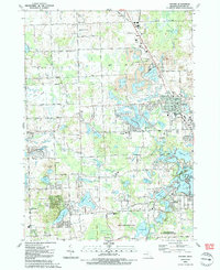 1991 Oxford1991 Print · USGSInland Oakland County in the early nineties shows a landscape of deep glacial lakes and heavy industry. Genealogists can locate family sites at Case Cem or Seymour Lake Cem, while others can trace the Grand Trunk Western RR and numerous gravel pits.2 unique versions available
 - 1991 Map of Lake Orion
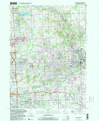
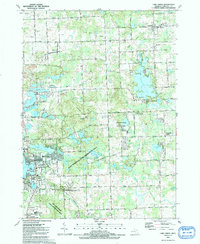 1991 Lake Orion1991 Print · USGSOakland County's lake country is captured here in the early 1990s as classic village centers and recreation areas began to merge. Researchers can locate family landmarks such as Kingsbury Cem, the historic Rudds Mill (Site), and the route of the Grand Trunk Western Railroad.
 - 1996 Map of Lake Orion, 1999 Print
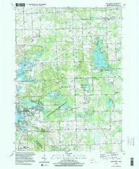 1996 Lake Orion1999 Print · USGSMid-century Oakland County transitions from a rural lake district to a prominent recreation hub in the 1990s. Trace old community centers like Leonard and Oakwood, or locate local landmarks such as Rudds Mill, Lakeville Cem, and the St Benedict Monastery.
 - 1997 Map of Pontiac North, 2000 Print
 1997 Pontiac North2000 Print · USGSOakland County underwent significant suburban maturation during the late nineties, blending its glacial lake landscapes with dense urban cores. Genealogists and local historians can trace legacy sites like Oak Hill Cemetery, the McMath-Hulbert Observatory, and numerous schools from Sashabaw Sch to Webster Sch.
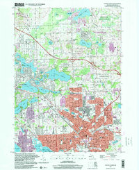
 - 1997 Map of Rochester, 2000 Print
 1997 Rochester2000 Print · USGSOakland County at the turn of the millennium shows the dense suburban growth around Rochester and Rochester Hills. Researchers can trace local lineage through Mt Avon Cemetery or explore the institutional footprint of Michigan Christian College and Oakland Community College.
End of results
Showing maps 1-5 of 5
Top cities near Orion Charter Township
- Sterling Heights historical maps
- Warren historical maps
- Troy historical maps
- Farmington Hills historical maps
- Shelby Charter Township historical maps
- Rochester Hills historical maps
See more
Top neighborhoods of Orion Charter Township
- Rudds Mill historical maps
- Gingellville historical maps
- Lake Orion Heights historical maps
- Mill Creek Village historical maps
- Round Tree Subdivision historical maps
Frequently asked questions
- What are the different types of historical maps available for Orion Charter Township?
- What is the oldest map of Orion Charter Township?
- Where can I purchase historical maps of Orion Charter Township for my home or office?
- Where can I download high-res historical maps of Orion Charter Township?
- Are there historical topographic maps available for Orion Charter Township?
- Is there historical aerial imagery available for Orion Charter Township?
- Where are historical maps of Orion Charter Township sourced from?