1930s Maps of Southfield, Michigan
Explore 5 historic maps of Southfield from the 1930s. These maps offer a rare glimpse into what life looked like during the 1930s — showing old roads, neighborhoods, homes, and landmarks that have changed or disappeared over time.
Whether you're researching your family's past, planning a metal detecting trip, or studying how Southfield's landscape evolved across the 1930s, these high-resolution maps are a powerful tool for exploring the history of this region.
- Focus on a specific era: All maps on this page are from the 1930s, giving you a focused view of this time period.
- See what’s changed: Compare century-old streets, trails, and buildings to today's modern landscape using overlays and satellite layers.
- Research with precision: Use these maps for genealogy, historical research, land use analysis, or educational projects.
- View, download, or print: Maps are fully viewable online in high resolution, and can be downloaded or printed for your own records.
Start exploring Southfield's history through authentic maps from the 1930s. This is your window into the past.
Southfield, MI maps
(5)- 1934 Map of Detroit
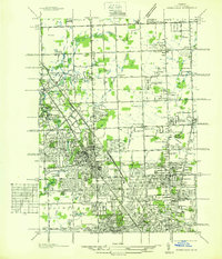
 1934 Detroit1934 Print · USGSThe Detroit riverfront and its rising industrial suburbs are captured here during the peak of the automotive boom. Genealogists and historians can trace the early footprints of the Ford Motor Co and local landmarks like Olivet Cemetery or the State Fair Grounds.
 - 1936 Map of Birmingham
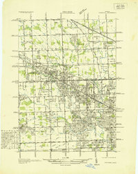
 1936 Birmingham1936 Print · USGSOakland County was undergoing a massive suburban transformation in the mid-thirties as the Detroit metropolitan area expanded northward. Trace the early development of Birmingham and Royal Oak, and find vanished landmarks like Charing Cross Sta or the Log Cabin High Sch.
 - 1936 Map of Redford
 1936 Redford1936 Print · USGSNorthwestern Detroit suburbs emerge from farm tracts during the mid-1930s, showing early neighborhoods and grid-road expansion. Genealogists can find numerous burial grounds like Grand Lawn Cem and landmarks such as Bell Br Community Ch and the Redford Post Office.
 - 1936 Map of Pontiac South
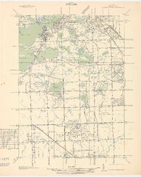 1936 Pontiac South1936 Print · USGSOakland County was rapidly evolving into a premier suburban and recreational district in the mid-1930s. Genealogists and local historians can trace legacy estates and institutions like St Marys College and Polish Seminary, Cranbrook Sch, and the Pine Lake Cem.2 unique versions available
 - 1936 Map of Royal Oak
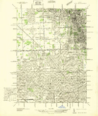 1936 Royal Oak1936 Print · USGSOakland County was rapidly developing north of Detroit during the mid-1930s, as residential grids expanded over former farmland. Genealogists can locate family homes near Southfield Ch or trace the early layout of Lathrup and Huntington Woods.
End of results
Showing maps 1-5 of 5
Top cities near Southfield
- Detroit historical maps
- Sterling Heights historical maps
- Warren historical maps
- Canton Township historical maps
- Livonia historical maps
- Dearborn historical maps
See more
Frequently asked questions
- What are the different types of historical maps available for Southfield?
- What is the oldest map of Southfield?
- Where can I purchase historical maps of Southfield for my home or office?
- Where can I download high-res historical maps of Southfield?
- Are there historical topographic maps available for Southfield?
- Is there historical aerial imagery available for Southfield?
- Where are historical maps of Southfield sourced from?