1940s Maps of Southfield, Michigan
Explore 4 historic maps of Southfield from the 1940s. These maps offer a rare glimpse into what life looked like during the 1940s — showing old roads, neighborhoods, homes, and landmarks that have changed or disappeared over time.
Whether you're researching your family's past, planning a metal detecting trip, or studying how Southfield's landscape evolved across the 1940s, these high-resolution maps are a powerful tool for exploring the history of this region.
- Focus on a specific era: All maps on this page are from the 1940s, giving you a focused view of this time period.
- See what’s changed: Compare century-old streets, trails, and buildings to today's modern landscape using overlays and satellite layers.
- Research with precision: Use these maps for genealogy, historical research, land use analysis, or educational projects.
- View, download, or print: Maps are fully viewable online in high resolution, and can be downloaded or printed for your own records.
Start exploring Southfield's history through authentic maps from the 1940s. This is your window into the past.
Southfield, MI maps
(4)- 1941 Map of Royal Oak
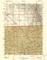 1941 Royal Oak1941 Print · USGSThe Detroit and Oakland County borderlands come into sharp focus in the late thirties as suburban neighborhoods began to fill the grid. Genealogists and local researchers can trace early residential blocks, parish schools like Gesu Sch, and prominent landmarks including the Detroit Zoological Park and Oakview Cem.2 unique versions available
 - 1942 Map of Redford
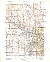 1942 Redford1942 Print · USGSNorthwest of Detroit during the early war years, this survey captures the transition from township farmsteads to suburban hubs. Trace family roots and local landmarks through sites like the Redford PO, Burns Airport, and Grand Lawn Cem.2 unique versions available
 - 1943 Map of Pontiac South
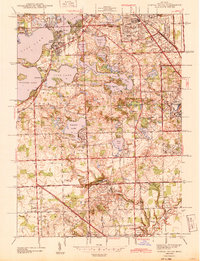 1943 Pontiac South1943 Print · USGSOakland County during the early 1940s shows a landscape of growing suburbs and extensive lakefront estates. Genealogists and historians can locate old landmarks like the St Marys College and Polish Seminary, Franklin Cem, and the German Sch.2 unique versions available
 - 1945 Map of Birmingham
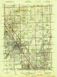 1945 Birmingham1945 Print · USGSOakland County was undergoing a massive suburban transformation in the years following the war. Researchers can trace the early residential grids of Birmingham and Berkley or locate local landmarks like the Log Cabin Sch and St Hugo Ch.
End of results
Showing maps 1-4 of 4
Top cities near Southfield
- Detroit historical maps
- Sterling Heights historical maps
- Warren historical maps
- Canton Township historical maps
- Livonia historical maps
- Dearborn historical maps
See more
Frequently asked questions
- What are the different types of historical maps available for Southfield?
- What is the oldest map of Southfield?
- Where can I purchase historical maps of Southfield for my home or office?
- Where can I download high-res historical maps of Southfield?
- Are there historical topographic maps available for Southfield?
- Is there historical aerial imagery available for Southfield?
- Where are historical maps of Southfield sourced from?