1930s Maps of Springfield Charter Township, Michigan
Explore 2 historic maps of Springfield Charter Township from the 1930s. These maps offer a rare glimpse into what life looked like during the 1930s — showing old roads, neighborhoods, homes, and landmarks that have changed or disappeared over time.
Whether you're researching your family's past, planning a metal detecting trip, or studying how Springfield Charter Township's landscape evolved across the 1930s, these high-resolution maps are a powerful tool for exploring the history of this region.
- Focus on a specific era: All maps on this page are from the 1930s, giving you a focused view of this time period.
- See what’s changed: Compare century-old streets, trails, and buildings to today's modern landscape using overlays and satellite layers.
- Research with precision: Use these maps for genealogy, historical research, land use analysis, or educational projects.
- View, download, or print: Maps are fully viewable online in high resolution, and can be downloaded or printed for your own records.
Start exploring Springfield Charter Township's history through authentic maps from the 1930s. This is your window into the past.
Springfield Charter Township, MI maps
(2)- 1936 Map of Highland
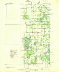 1936 Highland1936 Print · USGSOakland County's lake-rich landscape is captured in the mid-1930s, showing the early residential development around White Lake and the Huron River. Genealogists and local historians can trace the locations of the White Lake Center Sch, Seven Harbors, and the historic White Lake Cem.
 - 1936 Map of Clarkston
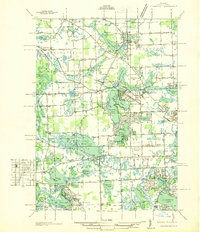 1936 Clarkston1936 Print · USGSOakland County during the mid-1930s shows a landscape of interconnected lakes and early suburban growth near the Clinton River. Genealogists and local historians can trace schoolhouse locations like Dublin Sch and Granger Sch, or explore the rail-era infrastructure of the Grand Trunk Western.
End of results
Showing maps 1-2 of 2
Top cities near Springfield Charter Township
- Farmington Hills historical maps
- Flint historical maps
- Waterford Township historical maps
- Novi historical maps
- West Bloomfield Township historical maps
- Pontiac historical maps
See more
Top neighborhoods of Springfield Charter Township
- Andersonville historical maps
- Springfield historical maps
- Davisburg historical maps
- Austin Corners historical maps
- Jossman Acres historical maps
Frequently asked questions
- What are the different types of historical maps available for Springfield Charter Township?
- What is the oldest map of Springfield Charter Township?
- Where can I purchase historical maps of Springfield Charter Township for my home or office?
- Where can I download high-res historical maps of Springfield Charter Township?
- Are there historical topographic maps available for Springfield Charter Township?
- Is there historical aerial imagery available for Springfield Charter Township?
- Where are historical maps of Springfield Charter Township sourced from?