1940s Maps of Springfield Charter Township, Michigan
Explore 7 historic maps of Springfield Charter Township from the 1940s. These maps offer a rare glimpse into what life looked like during the 1940s — showing old roads, neighborhoods, homes, and landmarks that have changed or disappeared over time.
Whether you're researching your family's past, planning a metal detecting trip, or studying how Springfield Charter Township's landscape evolved across the 1940s, these high-resolution maps are a powerful tool for exploring the history of this region.
- Focus on a specific era: All maps on this page are from the 1940s, giving you a focused view of this time period.
- See what’s changed: Compare century-old streets, trails, and buildings to today's modern landscape using overlays and satellite layers.
- Research with precision: Use these maps for genealogy, historical research, land use analysis, or educational projects.
- View, download, or print: Maps are fully viewable online in high resolution, and can be downloaded or printed for your own records.
Start exploring Springfield Charter Township's history through authentic maps from the 1940s. This is your window into the past.
Springfield Charter Township, MI maps
(7)- 1942 Map of Highland, 1965 Print
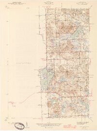
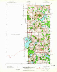 1942 Highland1965 Print · USGSOakland County's lake country is captured here in the early 1940s, showing a landscape of scattered rural schoolhouses and developing shoreline communities. Researchers can trace the local educational history at White Lake Sch or explore early lakeside life at Seven Harbors.
 - 1943 Map of Holly
 1943 Holly1943 Print · USGSThe Shiawassee River valley and its surrounding lake country are shown here in the early 1940s as a thriving network of rail towns and rural schools. Genealogists and local historians can trace family locations near Fenton, Holly, and the small settlement at Groveland Mills.
 - 1943 Map of Clarkston
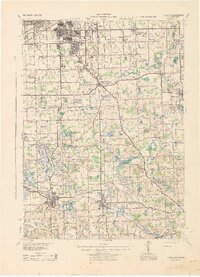
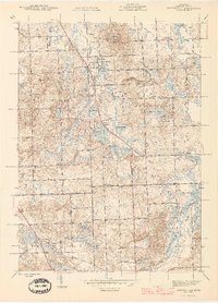
 1943 Clarkston1943 Print · USGSOakland County's lake country is captured here during the early war years, showing a landscape of interconnected waterways and expanding rail-side villages. Researchers can trace family sites at Lakeview Cem, locate early aviation history at Pontiac Municipal Airport, or follow the Grand Trunk Western RR through Waterford.2 unique versions available
 - 1943 Map of Ortonville, 1959 Print
 1943 Ortonville1959 Print · USGSDuring the early 1940s, the village of Ortonville and the surrounding townships remained a landscape of country schools and glacial lakes. Genealogists can locate family landmarks like Eaton Cem, Mt Bethel Ch, and the Seymour Lake Sch.
 - 1945 Map of Highland
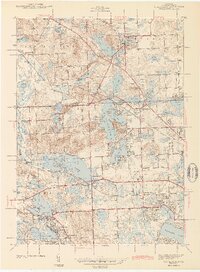
 1945 Highland1945 Print · USGSOakland County's lake country in the mid-1940s reveals a landscape of lakeside settlements and rural schools amidst a growing recreation area. Researchers can trace early family connections through sites like Seven Harbors, White Lake Sch, and the winding Huron River.2 unique versions available
 - 1945 Map of Ortonville
 1945 Ortonville1945 Print · USGSNorthwestern Oakland County during the mid-forties reveals a landscape of lakeside communities and rural schools just as post-war growth began. Genealogists can locate family landmarks like Jossman Acres, Mt Bethel Ch, and the Union Brandon Sch.2 unique versions available
 - 1945 Map of Davisburg
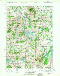
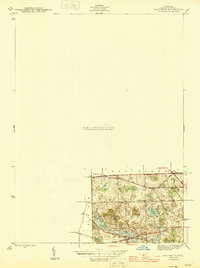 1945 Davisburg1945 Print · USGSOakland County's rural character remains evident in the mid-1940s, just before the post-war housing boom. Genealogists can trace early landmarks like Austin Corners, Brondige Sch, and the Bigelow Cem.3 unique versions available
End of results
Showing maps 1-7 of 7
Top cities near Springfield Charter Township
- Farmington Hills historical maps
- Flint historical maps
- Waterford Township historical maps
- Novi historical maps
- West Bloomfield Township historical maps
- Pontiac historical maps
See more
Top neighborhoods of Springfield Charter Township
- Andersonville historical maps
- Springfield historical maps
- Davisburg historical maps
- Austin Corners historical maps
- Jossman Acres historical maps
Frequently asked questions
- What are the different types of historical maps available for Springfield Charter Township?
- What is the oldest map of Springfield Charter Township?
- Where can I purchase historical maps of Springfield Charter Township for my home or office?
- Where can I download high-res historical maps of Springfield Charter Township?
- Are there historical topographic maps available for Springfield Charter Township?
- Is there historical aerial imagery available for Springfield Charter Township?
- Where are historical maps of Springfield Charter Township sourced from?