1930s Maps of Sylvan Lake, Michigan
Explore 2 historic maps of Sylvan Lake from the 1930s. These maps offer a rare glimpse into what life looked like during the 1930s — showing old roads, neighborhoods, homes, and landmarks that have changed or disappeared over time.
Whether you're researching your family's past, planning a metal detecting trip, or studying how Sylvan Lake's landscape evolved across the 1930s, these high-resolution maps are a powerful tool for exploring the history of this region.
- Focus on a specific era: All maps on this page are from the 1930s, giving you a focused view of this time period.
- See what’s changed: Compare century-old streets, trails, and buildings to today's modern landscape using overlays and satellite layers.
- Research with precision: Use these maps for genealogy, historical research, land use analysis, or educational projects.
- View, download, or print: Maps are fully viewable online in high resolution, and can be downloaded or printed for your own records.
Start exploring Sylvan Lake's history through authentic maps from the 1930s. This is your window into the past.
Sylvan Lake, MI maps
(2)- 1936 Map of Pontiac South
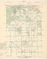 1936 Pontiac South1936 Print · USGSOakland County was rapidly evolving into a premier suburban and recreational district in the mid-1930s. Genealogists and local historians can trace legacy estates and institutions like St Marys College and Polish Seminary, Cranbrook Sch, and the Pine Lake Cem.2 unique versions available
 - 1936 Map of Pontiac North
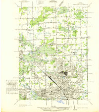 1936 Pontiac North1936 Print · USGSMid-century Oakland County is captured here at the cusp of modern suburbanization, where traditional townships meet the growing industrial city. Genealogists can locate family names and sites like Clintonville, Perry Mount Park Cem, and many local schools including Hallstead Sch.
End of results
Showing maps 1-2 of 2
Top cities near Sylvan Lake
- Detroit historical maps
- Livonia historical maps
- Troy historical maps
- Farmington Hills historical maps
- Rochester Hills historical maps
- Southfield historical maps
See more
Frequently asked questions
- What are the different types of historical maps available for Sylvan Lake?
- What is the oldest map of Sylvan Lake?
- Where can I purchase historical maps of Sylvan Lake for my home or office?
- Where can I download high-res historical maps of Sylvan Lake?
- Are there historical topographic maps available for Sylvan Lake?
- Is there historical aerial imagery available for Sylvan Lake?
- Where are historical maps of Sylvan Lake sourced from?