1930s Maps of Oceana County, Michigan
Explore 11 historic maps of Oceana County from the 1930s. These maps offer a rare glimpse into what life looked like during the 1930s — showing old roads, neighborhoods, homes, and landmarks that have changed or disappeared over time.
Whether you're researching your family's past, planning a metal detecting trip, or studying how Oceana County's landscape evolved across the 1930s, these high-resolution maps are a powerful tool for exploring the history of this region.
- Focus on a specific era: All maps on this page are from the 1930s, giving you a focused view of this time period.
- See what’s changed: Compare century-old streets, trails, and buildings to today's modern landscape using overlays and satellite layers.
- Research with precision: Use these maps for genealogy, historical research, land use analysis, or educational projects.
- View, download, or print: Maps are fully viewable online in high resolution, and can be downloaded or printed for your own records.
Start exploring Oceana County's history through authentic maps from the 1930s. This is your window into the past.
Oceana County, MI maps
(11)- 1931 Map of Hart NW
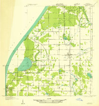 1931 Hart NW1931 Print · USGSOceana County’s coast and interior farmsteads are captured in the early 1930s, showing a landscape defined by small rural school districts and the lakefront. Researchers can trace family locations through sites like Wesley M E Ch, the village of Mears, and schools like Young Sch and Garver Sch.
 - 1931 Map of Custer SW
 1931 Custer SW1931 Print · USGSThe borderlands of Oceana and Mason County are captured in the early 1930s when rural education and township government anchored the community. Genealogists can locate family homesteads near Crystal and trace the paths to Fern Sch, Kidder Sch, or the Town Hall.
 - 1931 Map of Hart SE
 1931 Hart SE1931 Print · USGSOceana County at the dawn of the 1930s reveals a productive landscape of lakeside farms and rail-connected villages. Trace the early routes of U S Highway No 31 through New Era and Shelby, or locate family sites near Eagle Sch and Ferry Cem.
 - 1931 Map of Walkerville NE
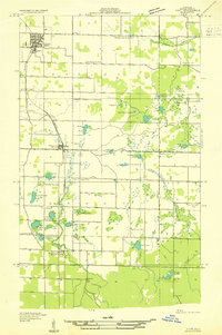
 1931 Walkerville NE1931 Print · USGSThe Oceana and Newaygo county lines meet in this early 1930s portrait of rural Michigan life. Genealogists and historians can trace several local schoolhouses like Gowdy Sch and Volney Sch near the village of Walkerville.
 - 1931 Map of Hart NE
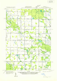
 1931 Hart NE1931 Print · USGSOceana County is shown in detail during the early 1930s, centered on the bustling village of HART and its surrounding agricultural townships. Researchers can trace rural genealogy through nearly a dozen local schoolhouses like Brooks Sch and landmarks such as the FAIR GROUNDS or St Josephs Ch.2 unique versions available
 - 1931 Map of Walkerville SW
 1931 Walkerville SW1931 Print · USGSOceana County in the early 1930s shows a landscape of winding river branches and rural township life. Genealogists and local historians can locate specific district landmarks like the Otto Town Hall or rural schoolhouses including Herrin Sch and Newman Sch.
 - 1931 Map of Walkerville NW
 1931 Walkerville NW1931 Print · USGSOceana County is shown in the early thirties as a network of rural school districts and family farms. Researchers can locate vanished rural institutions such as Elbridge Town Hall, Pine Grove Sch, and Cedar Sch along the Pentwater River corridor.
 - 1931 Map of Custer SE
 1931 Custer SE1931 Print · USGSThe rural borderlands of Mason and Oceana counties are captured here in the early 1930s, showing a landscape of small farmsteads and wetlands. Genealogists can locate family-named landmarks like Carr Sch and Waddell Sch or trace the South Branch Pere Marquette River.
 - 1931 Map of Walkerville SE
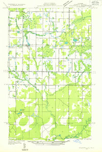
 1931 Walkerville SE1931 Print · USGSOceana County is shown in the early 1930s as a land of small farms and rural school districts centered around the village of Hesperia. Genealogists can trace family roots through a dense network of local schools including Cushman Sch and Sturtevant Sch along the White River.
 - 1932 Map of Ludington SW
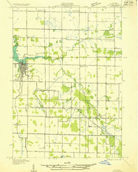
 1932 Ludington SW1932 Print · USGSThe Lake Michigan shoreline of Oceana County is captured here in the early thirties, showing the transition from maritime commerce to recreational use. Genealogists can trace family footprints near Pentwater or find old school sites like Star Valley Sch and Nickerson Sch.
 - 1932 Map of Ludington SE
 1932 Ludington SE1932 Print · USGSThe rural border of Mason and Oceana counties is captured here in the early thirties, showing a landscape of marshy creek bottoms and isolated farmsteads. Local historians can locate vanished community centers at Bucks Corner, Bethel Ch, and Wiley Sch.
End of results
Showing maps 1-11 of 11
Top cities of Oceana County
Frequently asked questions
- What are the different types of historical maps available for Oceana County?
- What is the oldest map of Oceana County?
- Where can I purchase historical maps of Oceana County for my home or office?
- Where can I download high-res historical maps of Oceana County?
- Are there historical topographic maps available for Oceana County?
- Is there historical aerial imagery available for Oceana County?
- Where are historical maps of Oceana County sourced from?