1960s Maps of Ogemaw County, Michigan
Explore 13 historic maps of Ogemaw County from the 1960s. These maps offer a rare glimpse into what life looked like during the 1960s — showing old roads, neighborhoods, homes, and landmarks that have changed or disappeared over time.
Whether you're researching your family's past, planning a metal detecting trip, or studying how Ogemaw County's landscape evolved across the 1960s, these high-resolution maps are a powerful tool for exploring the history of this region.
- Focus on a specific era: All maps on this page are from the 1960s, giving you a focused view of this time period.
- See what’s changed: Compare century-old streets, trails, and buildings to today's modern landscape using overlays and satellite layers.
- Research with precision: Use these maps for genealogy, historical research, land use analysis, or educational projects.
- View, download, or print: Maps are fully viewable online in high resolution, and can be downloaded or printed for your own records.
Start exploring Ogemaw County's history through authentic maps from the 1960s. This is your window into the past.
Ogemaw County, MI maps
(13)- 1963 Map of Luzerne, 1964 Print
 1963 Luzerne1964 Print · USGSOscoda County's forested interior is captured here in the early 1960s, showing the intersection of three major state and national forests. Genealogists and outdoorsmen can trace the early layout of Luzerne, the local Cem, and landmarks like the Luzerne Lookout Tower.
 - 1965 Map of Damon, 1966 Print
 1965 Damon1966 Print · USGSOgemaw County's forest lands and oil fields are captured here in the mid-1960s, showing the intersection of industry and natural conservation. Genealogists can locate family names at Damon Cem and Rose Cem, or trace the winding Old Railroad Grade.
 - 1965 Map of St. Helen NE, 1966 Print
 1965 St. Helen NE1966 Print · USGSOgemaw County's transition from timber harvesting to recreational forest is evident in this mid-sixties survey. Researchers can trace historic land use through the Old Railroad Grade, find family sites near Fisk Cem, and locate the Oil Well and Claypit that supported the local economy.2 unique versions available
 - 1965 Map of West Branch, 1966 Print
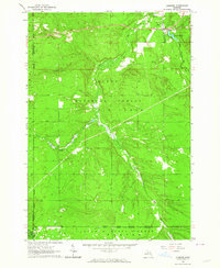
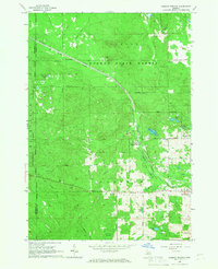
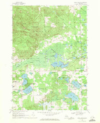
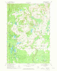
 1965 West Branch1966 Print · USGSThe Ogemaw County seat and its rural surroundings are captured in the mid-1960s as the rail and river networks defined local life. Trace family roots at St Josephs Cem, locate the old Miller Sch, or explore the tracks of the New York Central railroad.3 unique versions available
 - 1965 Map of Ogemaw Springs, 1966 Print
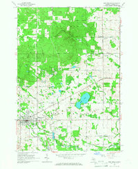
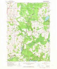
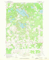
 1965 Ogemaw Springs1966 Print · USGSOgemaw County in the mid-1960s reveals a landscape of state forests, rail lines, and scattered rural landmarks. Genealogists and local historians can locate the Beaver Lake Cem, the Pleasant Hill Sch, and a notable Indian Mound near Ogemaw Springs.2 unique versions available
 - 1965 Map of Selkirk, 1966 Print
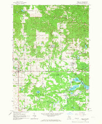
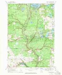
 1965 Selkirk1966 Print · USGSIn the mid-1960s, this portion of Ogemaw County was a mix of protected state forests and active rural communities centered on the Rifle River. Researchers can trace the locations of many local institutions, including Selkirk, Churchill Sch, and several Aboriginal Earthworks.2 unique versions available
 - 1965 Map of Rose City, 1967 Print
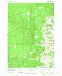
 1965 Rose City1967 Print · USGSOgemaw County thrived as a destination for forestry and recreation in the mid-sixties, centered on the growing community of Rose City. Local historians can trace family-named sites like Fayettes Corner, explore the Old Railroad Grade, and locate the Lane Heights Cem near Lupton.3 unique versions available
 - 1968 Map of Prescott, 1971 Print
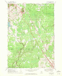
 1968 Prescott1971 Print · USGSNorthern Michigan in the late sixties reveals a landscape of rural villages and energy extraction. Trace local family history at Richland Cem or follow the Old Railroad Grade past Prescott and the Oil Wells near Maple Ridge.
 - 1968 Map of Sage Lake, 1971 Print
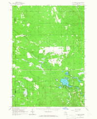
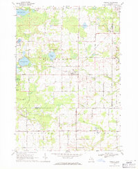
 1968 Sage Lake1971 Print · USGSThe Ogemaw and Iosco county line area comes to life in the late 1960s, showing a landscape defined by the expansive Sage Lake and the Ogemaw State Forest. Genealogists and local historians can trace family locations near Logan Corners, Logan Cemetery, and the Church of the Nazarene.
 - 1968 Map of South Branch, 1971 Print
 1968 South Branch1971 Print · USGSOgemaw County in the late sixties reveals a landscape of dense state and national forests and numerous glacial lakes. Genealogists and historians can locate South Branch and Goodar, trace the South Branch Au Sable River, and find the Oak Grove Cem.2 unique versions available
 - 1968 Map of Skidway Lake, 1971 Print
 1968 Skidway Lake1971 Print · USGSIn the late sixties, the Ogemaw County lakes region was a burgeoning center for recreation and industry. Researchers can trace the Old Railroad Grade near Alger, locate the Clayton Oil and Gas Field, and find local landmarks like St Stephens Ch.
 - 1968 Map of Sterling NW, 1971 Print
 1968 Sterling NW1971 Print · USGSNorthern Michigan's forested interior is captured in the late sixties, showing the intersection of Ogemaw, Gladwin, and Arenac counties. Genealogists and historians can trace the Bourret Cem or locate the Gustafson Airport and the Penn Central rail line.
 - 1969 Map of Edwards, 1971 Print
 1969 Edwards1971 Print · USGSCentral Michigan's lake-studded woodlands are captured here in the late sixties at the intersection of Ogemaw, Roscommon, and Gladwin counties. Genealogists and local historians can trace family-named routes and community landmarks like Edwards Cem, Oak Grove Ch, and the settlement of Edwards.
End of results
Showing maps 1-13 of 13
Top cities of Ogemaw County
Frequently asked questions
- What are the different types of historical maps available for Ogemaw County?
- What is the oldest map of Ogemaw County?
- Where can I purchase historical maps of Ogemaw County for my home or office?
- Where can I download high-res historical maps of Ogemaw County?
- Are there historical topographic maps available for Ogemaw County?
- Is there historical aerial imagery available for Ogemaw County?
- Where are historical maps of Ogemaw County sourced from?