Old Maps of Ontonagon County, Michigan for Academic Research
Study the evolution of Ontonagon County with 301 high-resolution historic maps. Whether you're teaching, researching, or modeling changes in land use, these maps provide essential visual documentation of urban, environmental, and geographic change.
- Analyze long-term change: Track patterns in development, transportation, and natural features.
- Ideal for environmental or urban studies: Support academic projects with primary historical map data.
- Use in the classroom or lab: Educators and researchers rely on these maps to bring historical context to life.
These maps are a powerful tool for teaching, research, and visualizing how Ontonagon County has changed over the decades.
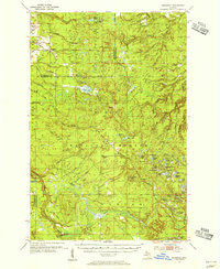
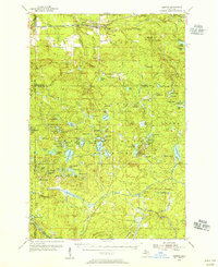
Ontonagon County, MI maps
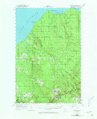
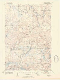
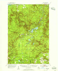
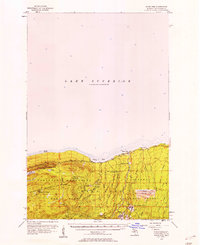
(301)- 1949 Map of Matchwood NW
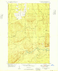 1949 Matchwood NW1949 Print · USGSUpper Peninsula timberlands and river valleys are captured here in the late 1940s as the forest recovered from the early logging era. Local historians can trace the remote Mac Intosh Cabin, locate the Norwich Lookout Tower, and find the hidden Cascade Falls.2 unique versions available
 - 1949 Map of White Pine
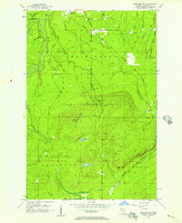
 1949 White Pine1949 Print · USGSThe Ontonagon County shoreline and Upper Peninsula timberlands are documented here in the late forties. Researchers can trace early mining and logging outposts like Silver City, None Such, and Sterling Camp near the edge of Porcupine Mountain State Park.2 unique versions available
 - 1949 Map of Bergland NE
 1949 Bergland NE1949 Print · USGSOntonagon County copper country is surveyed here in the late 1940s, showing the intersection of heavy industry and protected wilderness. Researchers can locate the White Pine Mine, the Bergland Lookout Tower, and remote camps like Hoffman Camp.
 - 1949 Map of Rockland, 1965 Print
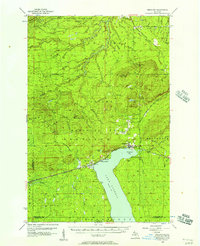
 1949 Rockland1965 Print · USGSThe Ontonagon copper country is shown in the late 1940s, a period when rail lines still connected remote settlements like Wainola and Paynesville. Local researchers can trace family landmarks like Wainola Ch, Rockland Cem, and the old Military Bridge.2 unique versions available
 - 1950 Map of Greenland, 1956 Print
 1950 Greenland1956 Print · USGSThe Upper Peninsula copper country is seen here at mid-century, where logging camps and mining operations defined the inland landscape. Researchers can trace the Copper Range Railroad and find historic sites like Adventure Mine or the remote Abbott-Fox Camp.2 unique versions available
 - 1951 Map of Rockland
 1951 Rockland1951 Print · USGSThe copper country of Ontonagon County comes alive in this mid-century survey of the Rockland and Bruce Crossing area. Genealogists and local historians can trace early railroad lines and find sites like Irish Hollow Cem, Wainola Ch, and the Gardner Lookout Tower.2 unique versions available
 - 1951 Map of Greenland
 1951 Greenland1951 Print · USGSIn the early fifties, Michigan’s Copper Country was a landscape of remote timber camps and maturing mining towns. Genealogists and industrial historians can trace the Copper Range RR through Greenland and Mass, or locate old work sites like Hilger Camp and the Adventure Mine.2 unique versions available
 - 1952 Map of Watersmeet, 1954 Print
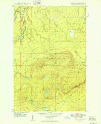
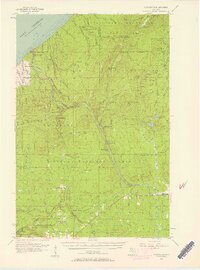
 1952 Watersmeet1954 Print · USGSThe western Upper Peninsula's rail and timber heartland is captured here in the early fifties. Researchers can locate vanished rural infrastructure like Maple Grove School, the Agate Church, and the expansive Bond Falls Flowage near Watersmeet.5 unique versions available
 - 1952 Map of Thayer, 1954 Print
 1952 Thayer1954 Print · USGSThe timberlands of the western Upper Peninsula are captured in the early fifties, centering on the railway corridor through the Ottawa National Forest. Researchers can trace the legacy of the Chicago and North Western line through Gogebic Station, Thayer, and the shores of Beatons Lake.4 unique versions available
 - 1954 Map of Rousseau, 1956 Print
 1954 Rousseau1956 Print · USGSHoughton and Ontonagon counties in the mid-1950s reveal a landscape defined by forestry and the reach of the rail lines. Researchers can trace the routes of the Chicago Milwaukee St Paul and Pacific Railroad and find sites like the Michigan College of Mining Forestry Camp and Rousseau.3 unique versions available
 - 1954 Map of Rockhouse Point, 1956 Print
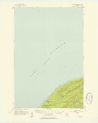
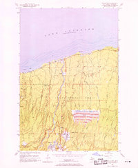
 1954 Rockhouse Point1956 Print · USGSThe Keweenaw Peninsula coastline remains largely wild in the mid-1950s, defined by the sweeping shores of Lake Superior. Researchers can trace the drainage of the Elm River and locate coastal landmarks like Stanton Park, Agate Beach, and Rockhouse Point.2 unique versions available
 - 1954 Map of Kenton, 1956 Print
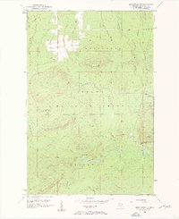
 1954 Kenton1956 Print · USGSThe Upper Peninsula rail corridors and timberlands are well-defined in the mid-1950s, centering on the crossing of the Duluth South Shore and Atlantic. Researchers can locate historic sites like the Kenton Cemetery, Holmes Dam, and the old Lookout Tower.3 unique versions available
 - 1954 Map of Winona, 1956 Print
 1954 Winona1956 Print · USGSIn the mid-1950s, the Copper Country south of Houghton was a landscape of industrial mines and deep forests. Genealogists and historians can trace the foundations of Winona, locate the Winona Mine, and find rural landmarks like the Misery Bay Sch and Simar Landing Field.3 unique versions available
 - 1955 Map of Ontonagon, 1956 Print
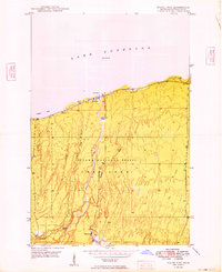
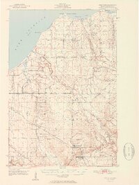
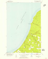
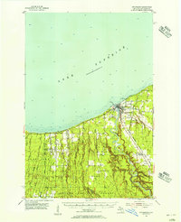 1955 Ontonagon1956 Print · USGSThe Lake Superior shoreline and the Ontonagon River mouth define this mid-century look at Michigan's Copper Country. Trace old transport routes and industry at Wood Spur, locate the Lighthouse, or find family names near Riverside Cem.2 unique versions available
 - 1956 Map of Carp River, 1957 Print
 1956 Carp River1957 Print · USGSThe Upper Peninsula shoreline meets the high ridges of the western Gogebic Range in the mid-1950s. Trace old mining sites like the LaFayette Mine and backcountry landmarks including Lake of the Clouds, Mirror Lake, and Lone Rock.4 unique versions available
 - 1956 Map of Bergland NE, 1957 Print
 1956 Bergland NE1957 Print · USGSOntonagon County in the mid-fifties is seen here during a period of active copper mining and forest management. Researchers can trace the industrial footprint of the White Pine Mine, the Bergland Lookout Tower, and the local Old Railroad Grade.2 unique versions available
 - 1956 Map of Bergland, 1957 Print
 1956 Bergland1957 Print · USGSUpper Peninsula timber and copper country come into focus in the mid-fifties as the railroad meets the shores of Lake Gogebic. Researchers can trace the rail sidings near Bergland, the workings of the White Pine Mine, and remote landmarks like Krobath Cabin.3 unique versions available
 - 1956 Map of Thomaston, 1957 Print
 1956 Thomaston1957 Print · USGSThe Upper Peninsula wilderness in the mid-fifties is captured here, showing the heavy industrial influence of the Chicago and North Western railroad. Researchers can trace the timber-era rail sidings at Tula and Manley Siding or locate the Underwood Lookout Tower.4 unique versions available
 - 1956 Map of White Pine, 1958 Print
 1956 White Pine1958 Print · USGSThe copper-rich shores of Lake Superior are shown here during a period of significant industrial activity in the mid-1950s. You can trace the extensive operations at the White Pine Mine, locate the historic settlement of Nonesuch, and follow the D S S & A rail line through the Ottawa National Forest.3 unique versions available
 - 1956 Map of Matchwood NW, 1958 Print
 1956 Matchwood NW1958 Print · USGSThe Upper Peninsula wilderness of the mid-fifties is captured here, showing the intersection of heavy industry and the Ottawa National Forest. Researchers can locate the Norwich Mine and trace the path of an Old Railroad Grade.3 unique versions available
 - 1956 Map of White Pine, 1958 Print
 1956 White Pine1958 Print · USGSCopper mining and rugged shoreline topography define the Ontonagon coast in the mid-fifties. Researchers can trace industrial developments like the White Pine Mine and Tailings Pond alongside landmarks like Lake of the Clouds.3 unique versions available
 - 1956 Map of Matchwood, 1958 Print
 1956 Matchwood1958 Print · USGSOntonagon County thrived as a railroad and timber hub in the mid-fifties, centered around the Duluth South Shore and Atlantic line. Local historians and genealogists can trace the settlements of Topaz and Ewen, locate the Norwich Mine, and find family sites near the Ewen Cem.2 unique versions available
 - 1958 Map of Hancock, 1967 Print
 1958 Hancock1967 Print · USGSThe Keweenaw Peninsula and Isle Royale are seen here during the mid-twentieth century as mining and maritime hubs. Trace the dense town layouts of Hancock and Calumet, or locate remote coastal markers like the Eagle Harbor Lighthouse and Rock of Ages Light.2 unique versions available
 - 1958 Map of Iron River, 1968 Print
 1958 Iron River1968 Print · USGSThe Upper Peninsula in the late fifties is captured here as a landscape of timber, iron, and rail. Genealogists and historians can trace rail stops like Mass Station or explore the coastlines of Lake Gogebic and Keweenaw Bay.3 unique versions available
 - 1960 Map of Iron River
 1960 Iron River1960 Print · USGSThe Upper Peninsula’s western reaches are shown in the late fifties, featuring the industrial infrastructure of the Copper Country and the vast Ottawa National Forest. Researchers can trace the rail lines of the Milwaukee Road through settlements like Bruce Crossing and the White Pine Mine.
Showing maps 1-25 of 301
Frequently asked questions
- What are the different types of historical maps available for Ontonagon County?
- What is the oldest map of Ontonagon County?
- Where can I purchase historical maps of Ontonagon County for my home or office?
- Where can I download high-res historical maps of Ontonagon County?
- Are there historical topographic maps available for Ontonagon County?
- Is there historical aerial imagery available for Ontonagon County?
- Where are historical maps of Ontonagon County sourced from?