1950s Maps of Bohemia Township, Michigan
Explore 7 historic maps of Bohemia Township from the 1950s. These maps offer a rare glimpse into what life looked like during the 1950s — showing old roads, neighborhoods, homes, and landmarks that have changed or disappeared over time.
Whether you're researching your family's past, planning a metal detecting trip, or studying how Bohemia Township's landscape evolved across the 1950s, these high-resolution maps are a powerful tool for exploring the history of this region.
- Focus on a specific era: All maps on this page are from the 1950s, giving you a focused view of this time period.
- See what’s changed: Compare century-old streets, trails, and buildings to today's modern landscape using overlays and satellite layers.
- Research with precision: Use these maps for genealogy, historical research, land use analysis, or educational projects.
- View, download, or print: Maps are fully viewable online in high resolution, and can be downloaded or printed for your own records.
Start exploring Bohemia Township's history through authentic maps from the 1950s. This is your window into the past.
Bohemia Township, MI maps
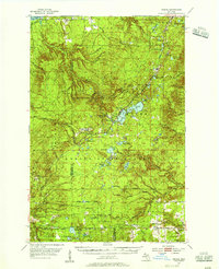
(7)- 1950 Map of Greenland, 1956 Print
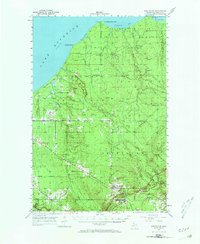 1950 Greenland1956 Print · USGSThe Upper Peninsula copper country is seen here at mid-century, where logging camps and mining operations defined the inland landscape. Researchers can trace the Copper Range Railroad and find historic sites like Adventure Mine or the remote Abbott-Fox Camp.2 unique versions available
 - 1951 Map of Greenland
 1951 Greenland1951 Print · USGSIn the early fifties, Michigan’s Copper Country was a landscape of remote timber camps and maturing mining towns. Genealogists and industrial historians can trace the Copper Range RR through Greenland and Mass, or locate old work sites like Hilger Camp and the Adventure Mine.2 unique versions available
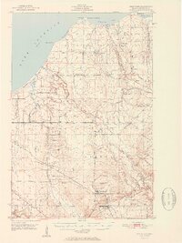
 - 1954 Map of Rousseau, 1956 Print
 1954 Rousseau1956 Print · USGSHoughton and Ontonagon counties in the mid-1950s reveal a landscape defined by forestry and the reach of the rail lines. Researchers can trace the routes of the Chicago Milwaukee St Paul and Pacific Railroad and find sites like the Michigan College of Mining Forestry Camp and Rousseau.3 unique versions available
 - 1954 Map of Rockhouse Point, 1956 Print
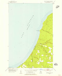 1954 Rockhouse Point1956 Print · USGSThe Keweenaw Peninsula coastline remains largely wild in the mid-1950s, defined by the sweeping shores of Lake Superior. Researchers can trace the drainage of the Elm River and locate coastal landmarks like Stanton Park, Agate Beach, and Rockhouse Point.2 unique versions available
 - 1954 Map of Winona, 1956 Print
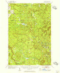
 1954 Winona1956 Print · USGSIn the mid-1950s, the Copper Country south of Houghton was a landscape of industrial mines and deep forests. Genealogists and historians can trace the foundations of Winona, locate the Winona Mine, and find rural landmarks like the Misery Bay Sch and Simar Landing Field.3 unique versions available
 - 1958 Map of Hancock, 1967 Print
 1958 Hancock1967 Print · USGSThe Keweenaw Peninsula and Isle Royale are seen here during the mid-twentieth century as mining and maritime hubs. Trace the dense town layouts of Hancock and Calumet, or locate remote coastal markers like the Eagle Harbor Lighthouse and Rock of Ages Light.2 unique versions available
 - 1958 Map of Iron River, 1968 Print
 1958 Iron River1968 Print · USGSThe Upper Peninsula in the late fifties is captured here as a landscape of timber, iron, and rail. Genealogists and historians can trace rail stops like Mass Station or explore the coastlines of Lake Gogebic and Keweenaw Bay.3 unique versions available
End of results
Showing maps 1-7 of 7
Top cities near Bohemia Township
Top neighborhoods of Bohemia Township
Frequently asked questions
- What are the different types of historical maps available for Bohemia Township?
- What is the oldest map of Bohemia Township?
- Where can I purchase historical maps of Bohemia Township for my home or office?
- Where can I download high-res historical maps of Bohemia Township?
- Are there historical topographic maps available for Bohemia Township?
- Is there historical aerial imagery available for Bohemia Township?
- Where are historical maps of Bohemia Township sourced from?