
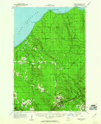
1950 Map of Greenland
USGS Topo · Published 1956About this map
Lake Superior dominates the northern edge of this copper country survey, where the rugged shoreline at Fourteenmile Point and its lighthouse give way to a landscape defined by timber and mineral extraction. The interior is densely dotted with logging outposts including Abbott-Fox Camp, Hilger Camp, and numbered sites like Camp 13, suggesting a period of active forestry across the Baraga and Greenland State Forests.
Find a feature on this map
55 named features on this map. Tap any name to fly to it.
Don’t see what you’re looking for? This feature index may not catch every label — zoom into the map to look around manually.
Map Details
Editions of this 1950 Greenland Map
2 editions found
Other maps of this area

1949 · Rockland
USGS Topo · 1:62,500

1951 · Rockland
USGS Topo · 1:62,500

1951 · Greenland
USGS Topo · 1:62,500

1954 · Rousseau
USGS Topo · 1:62,500

1954 · Rockhouse Point
USGS Topo · 1:24,000

1954 · Winona
USGS Topo · 1:62,500

1955 · Ontonagon
USGS Topo · 1:62,500

1956 · Matchwood
USGS Topo · 1:62,500

1958 · Hancock
USGS Topo · 1:250,000

1958 · Iron River
USGS Topo · 1:250,000