
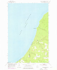
1954 Map of Rockhouse Point
USGS Topo · Published 1956About this map
Lake Superior dominates the western half of this mid-century survey, its deep blue contours meeting a shoreline defined by the rugged Keweenaw Peninsula. The landscape transition from the cold waters of Misery Bay north to the prominent Rockhouse Point highlights a coastal environment where industry and recreation overlap. Interior drainage is managed by the Elm River and its tributaries, including the South Branch and Little Elm River, which carve through the townships of Stanton and Bohemia. While much of the land remains wooded and sparse, the presence of Stanton Park and the long stretches of Agate Beach and Santa Monica Beach suggest a region valued for its natural lakefront access. Surveyed just after the post-war period, the map documents the boundary between Ontonagon and Houghton counties as it intersects this remote stretch of Michigan shoreline.
Find a feature on this map
12 named features on this map. Tap any name to fly to it.
Don’t see what you’re looking for? This feature index may not catch every label — zoom into the map to look around manually.
Map Details
Editions of this 1954 Rockhouse Point Map
2 editions found
Other maps of this area

1950 · Greenland
USGS Topo · 1:62,500

1951 · Greenland
USGS Topo · 1:62,500

1954 · Graveraet River
USGS Topo · 1:24,000

1954 · Beacon Hill
USGS Topo · 1:24,000

1954 · Winona
USGS Topo · 1:62,500

1958 · Hancock
USGS Topo · 1:250,000

1958 · Iron River
USGS Topo · 1:250,000

1960 · Iron River
USGS Topo · 1:250,000

1960 · Hancock
USGS Topo · 1:250,000

1961 · Iron River
USGS Topo · 1:250,000