1940s Maps of Ontonagon Township, Michigan
Explore 2 historic maps of Ontonagon Township from the 1940s. These maps offer a rare glimpse into what life looked like during the 1940s — showing old roads, neighborhoods, homes, and landmarks that have changed or disappeared over time.
Whether you're researching your family's past, planning a metal detecting trip, or studying how Ontonagon Township's landscape evolved across the 1940s, these high-resolution maps are a powerful tool for exploring the history of this region.
- Focus on a specific era: All maps on this page are from the 1940s, giving you a focused view of this time period.
- See what’s changed: Compare century-old streets, trails, and buildings to today's modern landscape using overlays and satellite layers.
- Research with precision: Use these maps for genealogy, historical research, land use analysis, or educational projects.
- View, download, or print: Maps are fully viewable online in high resolution, and can be downloaded or printed for your own records.
Start exploring Ontonagon Township's history through authentic maps from the 1940s. This is your window into the past.
Ontonagon Township, MI maps
(2)- 1949 Map of Matchwood NW
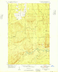 1949 Matchwood NW1949 Print · USGSUpper Peninsula timberlands and river valleys are captured here in the late 1940s as the forest recovered from the early logging era. Local historians can trace the remote Mac Intosh Cabin, locate the Norwich Lookout Tower, and find the hidden Cascade Falls.2 unique versions available
 - 1949 Map of Rockland, 1965 Print
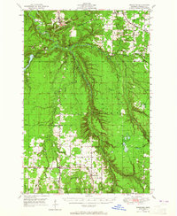 1949 Rockland1965 Print · USGSThe Ontonagon copper country is shown in the late 1940s, a period when rail lines still connected remote settlements like Wainola and Paynesville. Local researchers can trace family landmarks like Wainola Ch, Rockland Cem, and the old Military Bridge.2 unique versions available
End of results
Showing maps 1-2 of 2
Top cities near Ontonagon Township
Top neighborhoods of Ontonagon Township
Frequently asked questions
- What are the different types of historical maps available for Ontonagon Township?
- What is the oldest map of Ontonagon Township?
- Where can I purchase historical maps of Ontonagon Township for my home or office?
- Where can I download high-res historical maps of Ontonagon Township?
- Are there historical topographic maps available for Ontonagon Township?
- Is there historical aerial imagery available for Ontonagon Township?
- Where are historical maps of Ontonagon Township sourced from?