1950s Maps of Osceola County, Michigan
Explore 11 historic maps of Osceola County from the 1950s. These maps offer a rare glimpse into what life looked like during the 1950s — showing old roads, neighborhoods, homes, and landmarks that have changed or disappeared over time.
Whether you're researching your family's past, planning a metal detecting trip, or studying how Osceola County's landscape evolved across the 1950s, these high-resolution maps are a powerful tool for exploring the history of this region.
- Focus on a specific era: All maps on this page are from the 1950s, giving you a focused view of this time period.
- See what’s changed: Compare century-old streets, trails, and buildings to today's modern landscape using overlays and satellite layers.
- Research with precision: Use these maps for genealogy, historical research, land use analysis, or educational projects.
- View, download, or print: Maps are fully viewable online in high resolution, and can be downloaded or printed for your own records.
Start exploring Osceola County's history through authentic maps from the 1950s. This is your window into the past.
Osceola County, MI maps
(11)- 1954 Map of Traverse City, 1965 Print
 1954 Traverse City1965 Print · USGSNorthern Michigan’s vast lakeshores and timberlands are captured here in the mid-fifties, showing the region before the modern interstate era. Genealogists and researchers can trace rail connections like the Detroit and Mackinac RR or find old communities such as Suttons Bay, Elk Rapids, and Prudenville.4 unique versions available
 - 1954 Map of Midland, 1967 Print
 1954 Midland1967 Print · USGSMid-Michigan at the peak of the post-war era shows a landscape balancing industrial growth in Midland with the deep timberlands of the Manistee National Forest. Researchers can trace the legacy of the timber and rail era along the Pennsylvania RR or find family roots in river towns like Chesaning and Big Rapids.4 unique versions available
 - 1957 Map of Cadillac South, 1958 Print
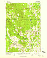
 1957 Cadillac South1958 Print · USGSOsceola and Wexford Counties are shown in the late fifties as a landscape of dense state forests and quiet rail towns. Genealogists can trace family names through the Maple Hill Cem and Richland Cem, or locate long-gone sites like the Sherman Sch and Mineral Springs Oil Field.3 unique versions available
 - 1957 Map of Luther, 1958 Print
 1957 Luther1958 Print · USGSThe Lake County timberlands and rural crossroads are captured here in the late fifties as small villages thrived amidst the state and national forests. Researchers can trace family roots at Banker Cem and North Park Cem, or locate landmarks like Clay Hill Ch and Luther.4 unique versions available
 - 1957 Map of Marion, 1958 Print
 1957 Marion1958 Print · USGSNorthern Osceola and Missaukee counties are shown here in the late fifties, defined by the Ann Arbor rail line and the Clam River network. Researchers can trace rural landmarks like the Prosper Sch, Greenwood Cem, and the Oil and Gas Storage Field.2 unique versions available
 - 1958 Map of Traverse City
 1958 Traverse City1958 Print · USGSNorthern Lower Michigan was a landscape of vast state forests and burgeoning lakeside retreats in the late fifties. Genealogists and historians can trace the rail corridors of the Ann Arbor RR and find established settlements from Elk Rapids to Houghton Lake.2 unique versions available
 - 1958 Map of Midland
 1958 Midland1958 Print · USGSCentral Michigan in the late fifties is captured here during a period of transition for its university towns and industrial hubs. Genealogists and researchers can trace family lines through old rail-stop towns like Breckenridge and Chesaning or locate property near the Muskegon River and Prairie Farm.
 - 1959 Map of Midland
 1959 Midland1959 Print · USGSMid-century Michigan comes alive in this survey of the central Lower Peninsula, from the streets of Grand Rapids to the Houghton Lake timberlands. Genealogists and rail fans can trace the Ann Arbor RR and Chesapeake and Ohio RR through towns like Big Rapids and Mount Pleasant.
 - 1959 Map of Lake, 1960 Print
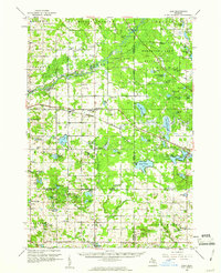 1959 Lake1960 Print · USGSOsceola and Mecosta Counties were a mix of timber-state forests and oil exploration during the late fifties. Researchers can trace rural landmarks from Sears to Brinton, including the County Home, local sites like Martin Sch, and the Chesapeake and Ohio rail line.2 unique versions available
 - 1959 Map of Evart, 1960 Print
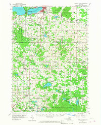
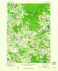 1959 Evart1960 Print · USGSOsceola and Mecosta counties are shown here in the late fifties, featuring the rail hubs and river valleys that shaped the region's growth. Genealogists and historians can locate rural schools like Watson Sch, the Osceola Oil Field, and family landmarks such as Crapo Cem.3 unique versions available
 - 1959 Map of Reed City, 1960 Print
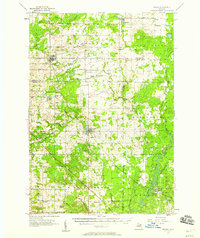
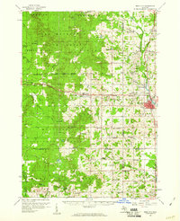 1959 Reed City1960 Print · USGSOsceola and Lake Counties are captured here in the late fifties, defined by the meeting of major rail lines and dense public forests. Researchers can locate dozens of rural landmarks, from the Fish Hatchery near Paris to schools like Rehkoff Sch and Zion Ch.2 unique versions available
End of results
Showing maps 1-11 of 11
Top cities of Osceola County
Frequently asked questions
- What are the different types of historical maps available for Osceola County?
- What is the oldest map of Osceola County?
- Where can I purchase historical maps of Osceola County for my home or office?
- Where can I download high-res historical maps of Osceola County?
- Are there historical topographic maps available for Osceola County?
- Is there historical aerial imagery available for Osceola County?
- Where are historical maps of Osceola County sourced from?